Filter: Categories of Wisconsin Historical Images
Filter: Subject of Islands
Filter: Categories of Wisconsin Historical Images
Filter: Subject of Islands

| Date: | 1910 |
|---|---|
| Description: | Photographic postcard view of "Helen's Isle" in a lake. |

| Date: | 04 15 1915 |
|---|---|
| Description: | A sketch of Little Lake Butte des Morts and the surrounding area, including Neenah and Menasha. |
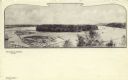
| Date: | 1900 |
|---|---|
| Description: | Black and white elevated view of Half Moon Lake and Island. Logs are in a boom in the lake. Caption reads: "Half Moon Lake and Island," and "Eau Claire, Wi... |
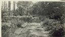
| Date: | |
|---|---|
| Description: | Main Road to the back of Hull Cottage on Madeline Island. |
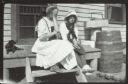
| Date: | 1913 |
|---|---|
| Description: | Two girls and a girl sit on the wooden stoop near a door. Grant's Point farm, Madeline Island. |

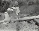
| Date: | 1915 |
|---|---|
| Description: | View looking towards shoreline of three men and one woman setting up a fire on the rocks for a picnic. There is a picnic basket on the log on the right, an... |
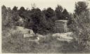
| Date: | 1915 |
|---|---|
| Description: | Quarry at Hermit Island (Wilson Island). Stones, plants and a foundation are in the foreground. In the background among trees is a wooden structure. |
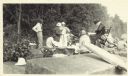
| Date: | |
|---|---|
| Description: | Group of people at a picnic on the shoreline at Bass Island. Names written on back of print: Mrs. Abernathy, chair; Mrs. Hull; Mrs. Baker. |
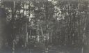
| Date: | |
|---|---|
| Description: | View through trees of "Lar-Board" (Baker's Cottage), later Hamilton Rose Cottage. |
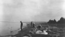
| Date: | 08 22 1916 |
|---|---|
| Description: | View along shoreline towards people at a Bear Island picnic. A man stands near the water, and two women and a another man are among the logs along the shor... |

| Date: | 1881 |
|---|---|
| Description: | This map is pen and ink on paper and shows part of the city of Menasha, local streets, Dendo Island, part of Lake Winnebago, and part of Little Lake Butte ... |

| Date: | 1902 |
|---|---|
| Description: | This map is a chart of Milwaukee Harbor that displays local streets, bridges, roads, railroads, public buildings, businesses, factories, dry docks, parks, ... |

| Date: | 1895 |
|---|---|
| Description: | Map showing the continents of the world with the Americas at the center. From left to right land masses names are: "Siberia, Chinese Empire, Australia, Nor... |

| Date: | 1836 |
|---|---|
| Description: | This map shows Havre Bay, a part of Maumee Bay, parts of Indian Island, Gard’s Island (Michigan), the Ottawa River, Vance River, creeks, and Ottawa Point (... |

| Date: | 1900 |
|---|---|
| Description: | This blue line print map shows land use, cables, U.S.L.S.S. walk and clearing, and front and rear range lights on the Porte des Morts Passage. Tree types a... |

| Date: | 1902 |
|---|---|
| Description: | This map shows shoals near Waugoshance Point. Lighthouses are labeled. Depths are shown by soundings and tints. Relief is shown by hachures. Inset includes... |

| Date: | 1906 |
|---|---|
| Description: | This map shows miles to other islands, harbors, canals, and passages. The South Fox ISL. LT and the Black Gas Buoy are colored in yellow and red. Depths ar... |

| Date: | 1893 |
|---|---|
| Description: | This map shows the depths of the East Neebish Rapids and the different types of minerals that make up the floor bed. Islands and Canada West is labeled. No... |

| Date: | 1925 |
|---|---|
| Description: | This map shows lakes, islands and bays. The Upper Peninsula of Michigan and Ontario are labeled. Three inset maps include the Upper end of St. Marys River ... |
If you didn't find the material you searched for, our Library Reference Staff can help.
Call our reference desk at 608-264-6535 or email us at: