 Filter: Categories of Wisconsin Historical Images
Filter: Subject of Islands
Filter: Categories of Wisconsin Historical Images
Filter: Subject of Islands

| Date: | 1836 |
|---|---|
| Description: | This is a cadastral map and shows proposed lot and block numbers for a paper city on the banks of the Rock River. Also shown are two public squares and som... |

| Date: | 1893 |
|---|---|
| Description: | Map of Wisconsin showing Michigan's upper peninsula, the northern portion of Illinois and part of eastern Minnesota. There is an inset map of Isle Royale i... |

| Date: | |
|---|---|
| Description: | Aerial view of Potawatomi State Park, with the Sturgeon Bay shoreline in the background. |

| Date: | 1971 |
|---|---|
| Description: | A topographical map of Namekagon Lake and the surrounding area. |

| Date: | 07 2001 |
|---|---|
| Description: | David Obey poses with Park Ranger Geoffrey Smith on the left and Martin Hanson on the right. They are standing on the beach with water and land in the back... |
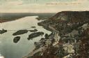
| Date: | 1902 |
|---|---|
| Description: | Elevated view of the city of Port Limon, Costa Rica with the Caribbean Sea in the background. Trees grow amongst the many commercial and residential buildi... |

| Date: | 03 24 1950 |
|---|---|
| Description: | Front cover of a farewell dinner menu from the Italian Line ship Saturnia, with two Commedia dell' Arte characters: Tartaglia, a rotund figure who w... |

| Date: | 1920 |
|---|---|
| Description: | View from beach across Spike Horn Bay towards Cana Island and the Cana Island Light. |
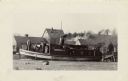
| Date: | 1931 |
|---|---|
| Description: | The Frank Braeger is moored on the shore of Jones Island with steam issuing from the pipe, with the crew posing on the boat. In the background a man... |

| Date: | |
|---|---|
| Description: | Letterhead of Johnson & Melaas, merchant tailors and cloth dealers, "Buyers of wool and Wisconsin leaf tobacco," with an engraving of a waterfront view of ... |

| Date: | 1931 |
|---|---|
| Description: | Fishermen from the Frank Braeger fishing tugboat are standing for a group portrait in front of their fishing nets on Jones Island. |

| Date: | 1931 |
|---|---|
| Description: | Two smiling fishermen stand before their fishing nets on Jones Island. There are floats attached to one net and a barrel with a jacket on top of it. |

| Date: | 05 01 1899 |
|---|---|
| Description: | Map showing the Schuylkill River with roads, ferries, and points of interest from Valley Forge to Philadelphia, Pennsylvania as it appeared during the Revo... |
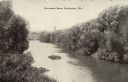
| Date: | 1910 |
|---|---|
| Description: | Elevated view looking up the Pecatonica River. Caption reads: "Pecatonica River, Darlington, Wis." |

| Date: | 1910 |
|---|---|
| Description: | Doctor Thorne was one of the members of Carrie's travel party. He is pictured here, in front of Victoria Falls on Livingstone Island. |

| Date: | 1910 |
|---|---|
| Description: | Photographic postcard of elevated view of the Wilcox Stone Mill, and part of Broadway showing the rear view of B.F. Smith's store below the hand-drawn arro... |

| Date: | 1916 |
|---|---|
| Description: | This map is mounted on cloth and shows lots and roads. An inset map is included that shows towns, lakes, rivers, and railroads within portions of the Dakot... |
| Date: | 1910 |
|---|---|
| Description: | Color enhanced aerial view of the village of DeSoto, looking north along the Mississippi River. Caption reads: "Bird's Eye View of the Village of De Soto, ... |
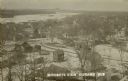
| Date: | 1920 |
|---|---|
| Description: | Black and white photographic postcard view of De Soto, taken from the cliff south of town, looking north along the Mississippi River. Caption reads: "A Vie... |
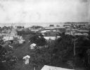
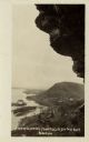
| Date: | 1910 |
|---|---|
| Description: | Elevated view of the town with snow on the ground. Houses are near an intersection in the foreground, and homes and commercial buildings are along the shor... |
If you didn't find the material you searched for, our Library Reference Staff can help.
Call our reference desk at 608-264-6535 or email us at: