 Filter: Categories of Wisconsin Historical Images
Filter: Subject of Islands
Filter: Categories of Wisconsin Historical Images
Filter: Subject of Islands

| Date: | 1929 |
|---|---|
| Description: | View from entrance of a cave looking out to the Mississippi River, a railroad bridge, all surrounded by a forest. There is a small island in the river. |

| Date: | 1929 |
|---|---|
| Description: | Elevated view from Signal Point of the Mississippi River, railroad and surrounding forest and wetlands. |
| Date: | 1945 |
|---|---|
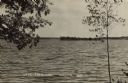
| Description: | Photographic postcard view from shoreline of Lake Eau Claire and a small island. Caption reads: "Lake Eau Claire, Augusta, Wis." |
| Date: | 1950 |
|---|---|
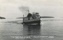
| Description: | Photographic postcard view of a fishing boat in Lake Superior with tourists on board. There is an island on the horizon. Caption reads: "'The Apostle Isla... |

| Date: | |
|---|---|
| Description: | Colorized postcard view over water towards boats and boaters at a resort. In the background are people and boats near a pier. The resort is among trees on ... |
| Date: | |
|---|---|
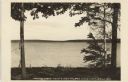
| Description: | Photographic postcard view of a lake from an island. Dwellings are on the far shoreline among trees. Caption reads: "Looking South from Kunz's Island, Bril... |

| Date: | 07 21 1925 |
|---|---|
| Description: | Dinner menu from the Hotel St. Catherine, with a color postcard at the top, meant to be detached and mailed, with a view of the hotel against a backdrop of... |

| Date: | 1828 |
|---|---|
| Description: | Map of the Louisville and Portland Canal on the Ohio River. The map shows Louisville, Shippingsport, Clarksville, Jeffersonville, Gravel Island, Corn Islan... |

| Date: | |
|---|---|
| Description: | An aerial view of Governor's Island. A cutout of an arrow has been added. |

| Date: | 05 16 1908 |
|---|---|
| Description: | View across water of Governor's Island. There is a far shoreline in the background on the left. |

| Date: | 1899 |
|---|---|
| Description: | A plat map of the township of Westport. |

| Date: | 2013 |
|---|---|
| Description: | Map is the most extensive endeavor to date to accurately locate and document both prehistoric place names and natural features of the Menominee language wi... |

| Date: | 1907 |
|---|---|
| Description: | View along bank of river towards a young girl walking in the grass near the shoreline. Behind her, a man and woman sit in a rowboat on the Rock River. They... |
| Date: | 1915 |
|---|---|
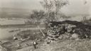
| Description: | Elevated view of the Mississippi River from a bluff. There is a farm and other houses along the shoreline, and in the foreground a boy stands on the bluff ... |
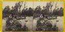
| Date: | 1860 |
|---|---|
| Description: | Two men and two women visit sit on a small, rocky island or natural bridge near water. Plants and trees are on shoreline behind them. |

| Date: | 1878 |
|---|---|
| Description: | View down Rock River towards a covered bridge near another bridge, with factories and the city in the background. |

| Date: | 1876 |
|---|---|
| Description: | This map is of the towns of Neenah and Menasha and shows existing and proposed canals. Water depths shown by soundings. Little Butte des Morts Lake, Doty I... |

| Date: | 1880 |
|---|---|
| Description: | This map of La Crosse shows the Chicago, Milwaukee and St. Paul Railroad, the Southern Minnesota Railroad and the Chicago, Dubuque and Minnesota Railroad, ... |

| Date: | 1891 |
|---|---|
| Description: | This map of La Crosse shows eighteen city wards in red, railroads, cemeteries, fair grounds, labeled streets, islands, and the Mississippi River. The left ... |

| Date: | 1893 |
|---|---|
| Description: | This map of La Crosse shows wards 1-20, streets, railroads, the Inter State Fair Grounds, islands, and the Mississippi River. Relief is shown by hachures. ... |
If you didn't find the material you searched for, our Library Reference Staff can help.
Call our reference desk at 608-264-6535 or email us at: