 Filter: Categories of Wisconsin Historical Images
Filter: Subject of Islands
Filter: Categories of Wisconsin Historical Images
Filter: Subject of Islands
| Date: | |
|---|---|
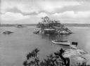
| Description: | Elevated view from Hubinger's Island featuring other islands, homes, and a boat. |
| Date: | |
|---|---|
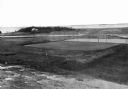
| Description: | Elevated view of golf links featuring Squaw Island in the distance. |

| Date: | |
|---|---|
| Description: | Park with stone-lined waterways, surrounded by woods. In the middle of the image is a small island with a rustic stone hut and in the background are stone... |
| Date: | 1920 |
|---|---|
| Description: | View down hill towards people near two buildings on a shoreline. Boats are out in the water. |
| Date: | |
|---|---|
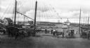
| Description: | A view toward a wharf with horse-drawn vehicles in the foreground, and a steamship in the distance. |
| Date: | |
|---|---|
| Description: | Etching of the "Attack upon Roanoke Island" by troops landing from naval vessels, after a painting by Chappel. |

| Date: | |
|---|---|
| Description: | Hand-drawn map of the area at the time of Pilgrim landing, drawn by Charles Blaskowikz. Includes commemorative historical notes. |
| Date: | |
|---|---|
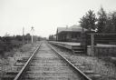
| Description: | View down railroad tracks which pass the Miscauno Island depot. A railroad signal is on the left, and the platform for the depot is on the right. |
| Date: | |
|---|---|
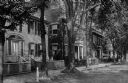
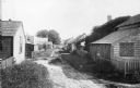
| Description: | Residences are shown on Main Street, exhibiting the colonial revival style. |
| Date: | |
|---|---|
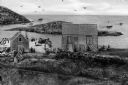
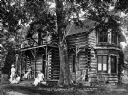
| Description: | Edmund Gardner's log cabin, purchased by Gardner in 1874. A group of women are on the porch. Caption reads: "Comm. Gardner's Log Cabin at Ballas Island." |
| Date: | |
|---|---|
| Description: | Women loading cargo onto a U.S. ship at St. Thomas in the Virgin Islands by way of baskets balanced on the tops of their heads. |
| Date: | |
|---|---|
| Description: | A view along the backs of cottages on a village lane in Siaconset, Nantucket Island. Shrubs line the unpaved road, and fences demarcate each cottage's yard... |
| Date: | 1918 |
|---|---|
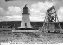
| Description: | View across rocks toward the Mount Desert Rock granite lighthouse, established in 1830 and automated in 1977, located thirty miles out to sea on a treeless... |
| Date: | 1908 |
|---|---|
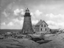
| Description: | A view of the Prudence Island granite lighthouse, established in 1852 and automated in 1972, more commonly known locally as the Sandy Point Lighthouse. The... |
| Date: | |
|---|---|
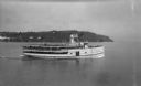
| Description: | View of the steamer ship "Islander" leaving Mackinac Island. Signs painted on the ship reads=: "Islander," "Arnold Line" and "St. Ignace Mackinac Island" (... |
| Date: | |
|---|---|
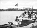
| Description: | Slightly elevated view of a crowd of people standing on boats lined up along a pier to watch a bi-winged airplane flying over the water. Large buildings ar... |
| Date: | 1910 |
|---|---|
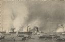
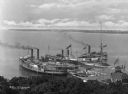
| Description: | Elevated view of three steamships arriving at Fox's Dock, an island in Lake Erie. People are waiting on the docks. A smaller ship is in the dock area as we... |

| Date: | 1910 |
|---|---|
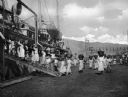
| Description: | View of tourists arriving on steamship. Many passengers are on the ship and the dock. |
| Date: | |
|---|---|
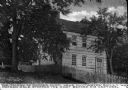
| Description: | The Mother Chick Tavern, where Nathan Hale, widely considered America's first spy during the American Revolutionary War, stopped the night before his captu... |

| Date: | 1744 |
|---|---|
| Description: | Paris: 1744. W 92⁰--W 76⁰/N 49⁰--N 41⁰. Scale [ca. 1:4,000,000] |
If you didn't find the material you searched for, our Library Reference Staff can help.
Call our reference desk at 608-264-6535 or email us at: