 Filter: Categories of Wisconsin Historical Images
Filter: Subject of Islands
Filter: Year of 1800-1899
Filter: Year of 1850-1859
Filter: Categories of Wisconsin Historical Images
Filter: Subject of Islands
Filter: Year of 1800-1899
Filter: Year of 1850-1859

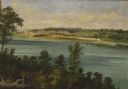
| Date: | 1856 |
|---|---|
| Description: | This landscape painting by Samuel Marsden Brookes and Thomas H. Stevenson depicts a broad view of the confluence of Bad Axe and Mississippi Rivers; site of... |

| Date: | 1852 |
|---|---|
| Description: | Illustration of four Indians on Madeline Island with a canoe in the water on the shore. |

| Date: | 1850 |
|---|---|
| Description: | Pastoral scene depicting a small bay on the Island of St. Ignace in Lake Superior with canoes on the rocky beach, two men conversing on a blanket in the fo... |

| Date: | 1850 |
|---|---|
| Description: | Pic Island on the north shore of Lake Superior. |

| Date: | 1856 |
|---|---|
| Description: | While passing through the English Channel in May 1856 Hölzlhuber viewed the Isle of Wight. "The island is located in the English Channel not far from Hamps... |

| Date: | 1856 |
|---|---|
| Description: | A hand-colored map of Wisconsin, showing the county boundaries, towns, cities, railroads, roads, lakes, rivers, bays, and the Lake Superior’s islands. In ... |
| Date: | 1856 |
|---|---|
| Description: | "At the Grand Kakalin where the river runs almost directly eastward, Brookes and Stevenson paused to paint two scenes. One was a broad landscape showing th... |

| Date: | 1859 |
|---|---|
| Description: | This map show plats including plat names, plat numbers, and some lot owner's names. Relief is shown by hachures. The map includes line drawings of Juneau B... |

| Date: | 1857 |
|---|---|
| Description: | This map shows section corners, quarter section corners, foundry, steam saw mill, steam grist mill, planning mill, court house, baptist church, congregatio... |

| Date: | 1852 |
|---|---|
| Description: | This map shows plat of three towns, sections, local streets, the Grand Chute Island, and part of the Fox River. The map includes 1 inset map: "Diagram of C... |

| Date: | 1857 |
|---|---|
| Description: | This map shows lot and block numbers, streets, railroad depots, locks, bridges, dams, canals, U.S. light house, college grounds, a steam boat landing, and ... |
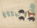
| Date: | 1851 |
|---|---|
| Description: | Pictograph E., Plate 63, "Kaizheosh, and his Band from Lake Vieu Desert. Michigan and Wisconsin." A group of symbols including birds, animals, a fish and a... |

| Date: | 1853 |
|---|---|
| Description: | A map of Wellfleet Harbor on Cape Cod Bay. |
If you didn't find the material you searched for, our Library Reference Staff can help.
Call our reference desk at 608-264-6535 or email us at: