| Date: | 1831 |
|---|---|
| Description: | Map of the city of Louisville, Kentucky on the Ohio River showing streets and numbered lots. The Ohio River, Corn Island, and the Louisville and Portland C... |

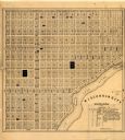
| Date: | 1836 |
|---|---|
| Description: | This is a cadastral map and shows proposed lot and block numbers for a paper city on the banks of the Rock River. Also shown are two public squares and som... |

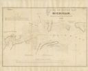
| Date: | 1836 |
|---|---|
| Description: | This map shows Havre Bay, a part of Maumee Bay, parts of Indian Island, Gard’s Island (Michigan), the Ottawa River, Vance River, creeks, and Ottawa Point (... |
If you didn't find the material you searched for, our Library Reference Staff can help.
Call our reference desk at 608-264-6535 or email us at: