Filter: Categories of Wisconsin Historical Images
Filter: Subject of Islands
Filter: Subject of water
Filter: Categories of Wisconsin Historical Images
Filter: Subject of Islands
Filter: Subject of water
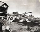
| Date: | 1945 |
|---|---|
| Description: | Marines dig foxholes into the sand on the beaches of Iwo Jima. The men are surrounded by military equipment, including a crane. An International Diesel cra... |
| Date: | |
|---|---|
| Description: | View of the Wisconsin River and the surrounding geological landforms. |
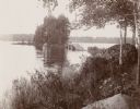
| Date: | |
|---|---|
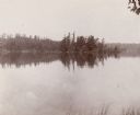
| Description: | View of a rural lake with a footbridge leading to a small island. |
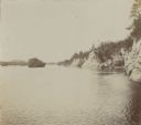
| Date: | |
|---|---|
| Description: | View of Clear Lake from shoreline. A small, tree-covered island is visible, with a tree-lined shore in the background. |

| Date: | |
|---|---|
| Description: | Elevated view of the Mississippi River and Horseshoe Island, an unusually shaped island that has water in its middle. |
| Date: | |
|---|---|
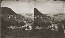
| Description: | Stereograph looking down the Mississippi River from the bluff at Reed's Landing. |

| Date: | |
|---|---|
| Description: | A view of Perry Island, a recent volcanic island. Caption reads: "Perry Island, recently thrown up in Behring Sea." |
| Date: | 1898 |
|---|---|
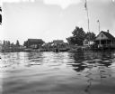
| Description: | View from water of boats docked near houses on Jones Island. To the right two flags are strung up flagpoles near a building with a covered porch, perhaps a... |
| Date: | |
|---|---|
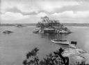
| Description: | Elevated view from Hubinger's Island featuring other islands, homes, and a boat. |
| Date: | |
|---|---|
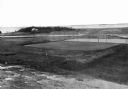
| Description: | Elevated view of golf links featuring Squaw Island in the distance. |

| Date: | |
|---|---|
| Description: | Park with stone-lined waterways, surrounded by woods. In the middle of the image is a small island with a rustic stone hut and in the background are stone... |
| Date: | |
|---|---|
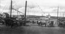
| Description: | A view toward a wharf with horse-drawn vehicles in the foreground, and a steamship in the distance. |
| Date: | |
|---|---|
| Description: | Etching of the "Attack upon Roanoke Island" by troops landing from naval vessels, after a painting by Chappel. |

| Date: | |
|---|---|
| Description: | Hand-drawn map of the area at the time of Pilgrim landing, drawn by Charles Blaskowikz. Includes commemorative historical notes. |
| Date: | |
|---|---|
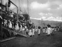
| Description: | Women loading cargo onto a U.S. ship at St. Thomas in the Virgin Islands by way of baskets balanced on the tops of their heads. |
| Date: | 1918 |
|---|---|
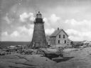
| Description: | View across rocks toward the Mount Desert Rock granite lighthouse, established in 1830 and automated in 1977, located thirty miles out to sea on a treeless... |
| Date: | |
|---|---|
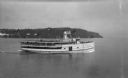
| Description: | View of the steamer ship "Islander" leaving Mackinac Island. Signs painted on the ship reads=: "Islander," "Arnold Line" and "St. Ignace Mackinac Island" (... |
| Date: | |
|---|---|
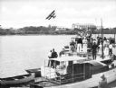
| Description: | Slightly elevated view of a crowd of people standing on boats lined up along a pier to watch a bi-winged airplane flying over the water. Large buildings ar... |
| Date: | 1910 |
|---|---|
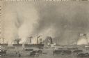
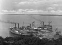
| Description: | Elevated view of three steamships arriving at Fox's Dock, an island in Lake Erie. People are waiting on the docks. A smaller ship is in the dock area as we... |
If you didn't find the material you searched for, our Library Reference Staff can help.
Call our reference desk at 608-264-6535 or email us at: