 Filter: Categories of Wisconsin Historical Images
Filter: Subject of Islands
Filter: Subject of water
Filter: Categories of Wisconsin Historical Images
Filter: Subject of Islands
Filter: Subject of water

| Date: | 1840 |
|---|---|
| Description: | This map, one of a series made by Thomas Jefferson Cram of the U.S. Topographical Engineers from personal surveys, shows the portage connecting the Wiskons... |

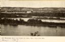
| Date: | 1910 |
|---|---|
| Description: | Elevated view from hill of a steamer at Point Douglas going upstream on the Mississippi River. Caption reads: "Mississippi River at Prescott, Wis." |

| Date: | |
|---|---|
| Description: | Plat map of the east central part of the city. |

| Date: | 1910 |
|---|---|
| Description: | Wisconsin Geological and Natural History Survey, by Lawrence Martin reproduced from a model of the state prepared by W.O. Hotchkiss and F.T. Thwaites and m... |
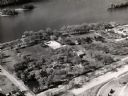
| Date: | 1960 |
|---|---|
| Description: | Aerial view of Villa Louis on the Mississippi River, and adjacent buildings. |
| Date: | 1905 |
|---|---|
| Description: | View looking toward old Diamond Jo Warehouse, before the bridge was built. Caption reads: "Mississippi River and Prairie du Chien, Wis., from Iowa Side". |
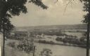
| Date: | 1910 |
|---|---|
| Description: | View from the bluffs in or near McGregor, Iowa. A fence and trees are in the foreground. |
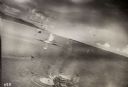
| Date: | 10 22 1943 |
|---|---|
| Description: | View across water of Mushu Island in the distance. There is a ship in the foreground, an airplane above, and the appearance of explosions in the water. |

| Date: | 1842 |
|---|---|
| Description: | American Fur Company with both Mission churches. Sketch purportedly by a Native American youth. Probably an overpainted photographic copy enlargement. Pape... |

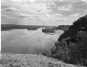
| Date: | 1954 |
|---|---|
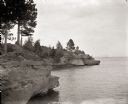
| Description: | View looking west from Eagle Bluff toward Nicolet Bay, the Strawberry Islands, and Chambers Island. Three people are sitting on the stone wall of the overl... |

| Date: | |
|---|---|
| Description: | A family kayaks in front of rock walls at the Apostle Islands. |
| Date: | 08 03 1946 |
|---|---|
| Description: | View of the Wisconsin River from Cactus Bluff. |
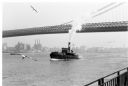
| Date: | 1969 |
|---|---|
| Description: | The Island's Edge, Williamsburg Bridge, East River. |
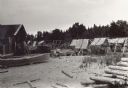
| Date: | 1915 |
|---|---|
| Description: | Building, boats, and fish net drying reels on South Twin Island in the Apostle Islands archipelago. |
| Date: | 1950 |
|---|---|
| Description: | Lighthouse on Outer Island of the Apostle Islands. |
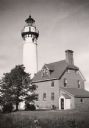
| Date: | |
|---|---|
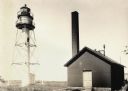
| Description: | La Pointe Light on Long Island (Apostle Islands), Chequamegon Bay, Lake Superior. |
| Date: | 1915 |
|---|---|
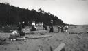
| Description: | Picnic on beach of one of the Apostle Islands, Lake Superior. Image includes Mrs. Chute, Mrs. Webb., Mrs. Hull, H.W. Rogers and Mr. Chute. |
| Date: | 08 29 1922 |
|---|---|
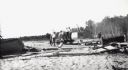
| Description: | Men and boys are on a hand-pump rail cart on a Michigan Island beach, Lake Superior. A young girl is walking on the right. |
| Date: | 1900 |
|---|---|
| Description: | View of Hougton Point and Bayfield from Madeline Island. |
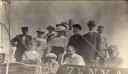
| Date: | 1917 |
|---|---|
| Description: | Group of people on boat "Zenya" at Hermit Island boat landing. L. to r. in back: Captain Angus; Mrs. Stickae; Florence Baker; Mrs. Baker; Elizabeth Abern... |
If you didn't find the material you searched for, our Library Reference Staff can help.
Call our reference desk at 608-264-6535 or email us at: