Filter: Categories of Wisconsin Historical Images
Filter: Subject of Islands
Filter: Subject of transportation
Filter: Categories of Wisconsin Historical Images
Filter: Subject of Islands
Filter: Subject of transportation

| Date: | 1905 |
|---|---|
| Description: | View across field and fence downhill towards the town of Fish Creek and the bay. Caption reads: "Greetings from Fish Creek, Wis." |

| Date: | 1956 |
|---|---|
| Description: | Aerial view looking northeast from a point over the east end of Middleton, showing the west end of Lake Mendota (right mid-ground). Fox Bluff juts into the... |
| Date: | 1920 |
|---|---|
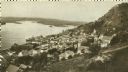
| Description: | Elevated view of Fountain City with the Mississippi River in the background. |
| Date: | 1925 |
|---|---|
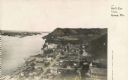
| Description: | Elevated view of Genoa. Caption reads: "Bird's Eye View, Genoa, Wis." The St. Charles Borromeo Catholic Church is in the right foreground. Railroad tracks ... |

| Date: | 1929 |
|---|---|
| Description: | Ferryboat landing, with the boats providing service between Gills Rock and Washington Island. |

| Date: | 1862 |
|---|---|
| Description: | An image from a sketchbook of "The Gunboats at No. 10 — Eve of Arrival before the I'sld". The drawing appears to be from the deck of a ship showing several... |
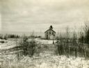
| Date: | |
|---|---|
| Description: | Exterior view of the "Pottawatomie" lighthouse in snowy expanse of land, with the lake in the background. |

| Date: | 1955 |
|---|---|
| Description: | Aerial view of La Crosse, with Onalaska in the background. The highway is U.S. Highway 53 and the State Highway 35. |

| Date: | 1844 |
|---|---|
| Description: | Map of Wisconsin including Lakes Michigan and Superior. Inset includes "N.W. Part of Wiskonsan." |
| Date: | 1910 |
|---|---|
| Description: | View from pier towards the Old Mission in La Pointe on Madeline Island. Men are sitting at the shoreline. Caption reads: "Apostle Islands, Wis. Madeline Is... |
| Date: | 1925 |
|---|---|
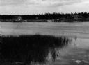
| Description: | Washington Island, including field and fence, with buildings, automobiles, and a large ship in the distance. |
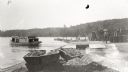
| Date: | 1929 |
|---|---|
| Description: | One of the four harbors on Washington Island. There is a man on a pier or dock in the foreground, and a boat approaching on the left. A tree-lined shorelin... |
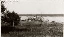
| Date: | 1910 |
|---|---|
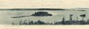
| Description: | View of Sawyer Harbor as seen from Government Bluff. |
| Date: | 10 28 1938 |
|---|---|
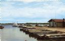
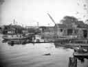
| Description: | Docks and shanties at Jones Island, with smokestacks and cranes in the background. |

| Date: | |
|---|---|
| Description: | A drawing from Harney's "History of Winnebago County" of E.L. Mathewson's home on Doty Island. |

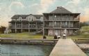
| Date: | 1948 |
|---|---|
| Description: | View from a pier of rowboats and a cabin at the Island Resort on Lake Ripley. |

| Date: | 1769 |
|---|---|
| Description: | Manuscript map. Scale: about 80 British statue miles to 1 inch. |
If you didn't find the material you searched for, our Library Reference Staff can help.
Call our reference desk at 608-264-6535 or email us at: