 Filter: Categories of Wisconsin Historical Images
Filter: Subject of Islands
Filter: Subject of transportation
Filter: Categories of Wisconsin Historical Images
Filter: Subject of Islands
Filter: Subject of transportation

| Date: | 1856 |
|---|---|
| Description: | A hand-colored map of Wisconsin, showing the county boundaries, towns, cities, railroads, roads, lakes, rivers, bays, and the Lake Superior’s islands. In ... |

| Date: | 1939 |
|---|---|
| Description: | This map shows the towns to Gingles, Sanborn, and Guney as well as Chequamegon Bay, Kakagon River, White River, Marengo River, Bad River, Potato River, Vau... |

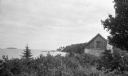
| Date: | 1938 |
|---|---|
| Description: | View of a house on Nebraska Row on Madeline Island. In the foreground is a flag pole, bench, path, lawn and trees. On the left are docks from the lake shor... |

| Date: | 1884 |
|---|---|
| Description: | A detailed, hand-colored map of Wisconsin and the western portion of Michigan’s Upper Peninsula, which also includes an inset of Isle Royale in Lake Superi... |
| Date: | |
|---|---|
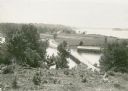
| Description: | Elevated view overlooking a road leading toward water, a boathouse, cabins, and a lake, most likely Jackson Lake. The shoreline on the far top right is ide... |

| Date: | |
|---|---|
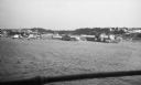
| Description: | View of a dirt road, cleared land, Jackson Lake and shoreline. Off to the far right is where the Nature Lovers Paradise resort cottages were located. A sig... |
| Date: | 1923 |
|---|---|
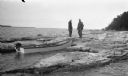
| Description: | Two men, including Ferdinand L. (Fedy) Hotz, left, stand on the west shore of Spider Island off Door County. There is a small boat with an outboard motor ... |
| Date: | 07 1923 |
|---|---|
| Description: | View of Mackinac Island from a wooden pier. There are large houses, some with turrets, facing the water. |
| Date: | 07 1923 |
|---|---|
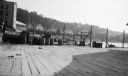
| Description: | View of Mackinac Island from a boat offshore. There are two large wooden piers with warehouses, and a beach on the right. Commercial buildings line the wat... |
| Date: | 1926 |
|---|---|
| Description: | View of rustic cabin with a large stone chimney standing by the shore. There is another house or boathouse in the far background near the remains of a pier... |

| Date: | 1904 |
|---|---|
| Description: | A young Aldo Leopold is posing smiling, wearing a jacket and bow tie while sitting on a pier. He is vacationing in the Cheneaux Islands. A shoreline with b... |

| Date: | 1881 |
|---|---|
| Description: | A hand-colored, cloth mounted, sectional map of Wisconsin showing the township grid, completed and proposed railroads, counties, towns, cities, villages. T... |

| Date: | 1882 |
|---|---|
| Description: | A hand-colored, sectional map of Wisconsin showing the township grid, completed and proposed railroads, counties, towns, cities, villages. The map also inc... |

| Date: | |
|---|---|
| Description: | View of wagons and carriages lined up on a road on Concordia Island for a picnic. |

| Date: | 06 1900 |
|---|---|
| Description: | Groups of people cross a wooden bridge on Concordia, later Tivoli, Island. |

| Date: | 1935 |
|---|---|
| Description: | An International C-55 truck works to build a breakwater at Port Allen on the island of Kauai. |

| Date: | 1907 |
|---|---|
| Description: | A map of the eastern portion of the Apostle Islands group, and a detailed map of Gull Island showing the relief on the island, are included here, along wit... |

| Date: | 1920 |
|---|---|
| Description: | A map of the Nelson-Dewey State Park at the confluence of the Mississippi and Wisconsin rivers, showing the topographical features of the area, as well as ... |

| Date: | 1916 |
|---|---|
| Description: | This Wisconsin Conservation Commission map from 1916 shows Peninsula State Park in the Town of Gibraltar, Door County, Wisconsin. Depicted are open and pla... |

| Date: | 1916 |
|---|---|
| Description: | This version of a 1916 Wisconsin Conservation Commission map shows Peninsula State Park in the Town of Gibraltar, Door County, Wisconsin. Depicted are open... |
If you didn't find the material you searched for, our Library Reference Staff can help.
Call our reference desk at 608-264-6535 or email us at: