 Filter: Categories of Wisconsin Historical Images
Filter: Subject of Islands
Filter: Subject of transportation
Filter: Subject of persons
Filter: Categories of Wisconsin Historical Images
Filter: Subject of Islands
Filter: Subject of transportation
Filter: Subject of persons
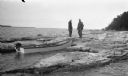
| Date: | 1923 |
|---|---|
| Description: | Two men, including Ferdinand L. (Fedy) Hotz, left, stand on the west shore of Spider Island off Door County. There is a small boat with an outboard motor ... |
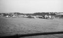
| Date: | 07 1923 |
|---|---|
| Description: | View of Mackinac Island from a wooden pier. There are large houses, some with turrets, facing the water. |
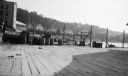
| Date: | 07 1923 |
|---|---|
| Description: | View of Mackinac Island from a boat offshore. There are two large wooden piers with warehouses, and a beach on the right. Commercial buildings line the wat... |
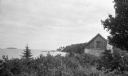
| Date: | 1926 |
|---|---|
| Description: | View of rustic cabin with a large stone chimney standing by the shore. There is another house or boathouse in the far background near the remains of a pier... |

| Date: | 1904 |
|---|---|
| Description: | A young Aldo Leopold is posing smiling, wearing a jacket and bow tie while sitting on a pier. He is vacationing in the Cheneaux Islands. A shoreline with b... |

| Date: | |
|---|---|
| Description: | View of wagons and carriages lined up on a road on Concordia Island for a picnic. |

| Date: | 06 1900 |
|---|---|
| Description: | Groups of people cross a wooden bridge on Concordia, later Tivoli, Island. |

| Date: | 1935 |
|---|---|
| Description: | An International C-55 truck works to build a breakwater at Port Allen on the island of Kauai. |

| Date: | 1899 |
|---|---|
| Description: | Map of Door County with inset photograph of Sturgeon Bay City. |
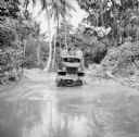
| Date: | 08 15 1943 |
|---|---|
| Description: | Three soldiers in a truck drive through mud on Kiriwina Island in the Solomon Sea, New Guinea (present day Papua New Guinea). Jungle foliage is in the back... |
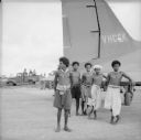
| Date: | 08 15 1943 |
|---|---|
| Description: | Indigenous men stand by a tail section as they watch planes take off and land at the Kiriwina Airfield on Kiriwina Island in the Solomon Sea, New Guinea (p... |
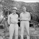
| Date: | 08 22 1943 |
|---|---|
| Description: | Major Howard Pagel (left) of Ladysmith, Wisconsin, and Captain Walter King (right) of Waco, Texas, stand together in front of the airfield aid station at t... |
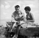
| Date: | 08 24 1943 |
|---|---|
| Description: | An indigenous woman wearing a grass shirt sits on a carved boat with Robert Doyle on the shore of Kiriwina Island in the Solomon Sea, New Guinea (present d... |

| Date: | 08 24 1899 |
|---|---|
| Description: | Pen-and-ink and color on paper. Also shows probable routes of the French explorers Constant le Marchand de Lignery in 1728 and Louis de la Porte de Louvign... |

| Date: | 1929 |
|---|---|
| Description: | View from entrance of a cave looking out to the Mississippi River, a railroad bridge, all surrounded by a forest. There is a small island in the river. |

| Date: | 1929 |
|---|---|
| Description: | Elevated view from Signal Point of the Mississippi River, railroad and surrounding forest and wetlands. |
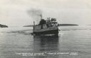
| Date: | 1950 |
|---|---|
| Description: | Photographic postcard view of a fishing boat in Lake Superior with tourists on board. There is an island on the horizon. Caption reads: "'The Apostle Isla... |

| Date: | |
|---|---|
| Description: | Colorized postcard view over water towards boats and boaters at a resort. In the background are people and boats near a pier. The resort is among trees on ... |

| Date: | 1878 |
|---|---|
| Description: | View down Rock River towards a covered bridge near another bridge, with factories and the city in the background. |

| Date: | 1712 |
|---|---|
| Description: | Engraved double-hemispherical world map by Moll, included in his atlas The world described, or, A new and correct sett of maps: shewing the kingdoms and st... |
If you didn't find the material you searched for, our Library Reference Staff can help.
Call our reference desk at 608-264-6535 or email us at: