 Filter: Categories of Wisconsin Historical Images
Filter: Subject of Islands
Filter: Subject of transportation
Filter: County of Bayfield
Filter: Categories of Wisconsin Historical Images
Filter: Subject of Islands
Filter: Subject of transportation
Filter: County of Bayfield

| Date: | 1886 |
|---|---|
| Description: | Bird's-eye view of Bayfield, county seat of Bayfield County. On the lower left side is an inset for Bayfield and the Apostle Islands. |

| Date: | 1886 |
|---|---|
| Description: | Bird's-eye map of Washburn on Lake Superior. There is an inset of Washburn, Chequamagon and the Apostle Islands. |

| Date: | 1910 |
|---|---|
| Description: | Bird's-eye view looking east, with Washburn Harbor at center and Chequamegon Bay in Lake Superior covering most of the upper image. Streets with buildings... |
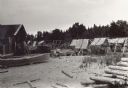
| Date: | 1915 |
|---|---|
| Description: | Building, boats, and fish net drying reels on South Twin Island in the Apostle Islands archipelago. |
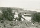
| Date: | |
|---|---|
| Description: | Elevated view overlooking a road leading toward water, a boathouse, cabins, and a lake, most likely Jackson Lake. The shoreline on the far top right is ide... |

| Date: | |
|---|---|
| Description: | View of a dirt road, cleared land, Jackson Lake and shoreline. Off to the far right is where the Nature Lovers Paradise resort cottages were located. A sig... |

| Date: | 1952 |
|---|---|
| Description: | This map of the northern parts of the Chequamegon Bay area in Bayfield and Ashland counties, Wisconsin, shows trails, roads, railroads, stations, the towns... |
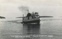
| Date: | 1950 |
|---|---|
| Description: | Photographic postcard view of a fishing boat in Lake Superior with tourists on board. There is an island on the horizon. Caption reads: "'The Apostle Isla... |

| Date: | 1971 |
|---|---|
| Description: | A topographical map of Namekagon Lake and the surrounding area. |

| Date: | 1929 |
|---|---|
| Description: | Aerial view of Lake Namakagon, showing the roads that connect Anderson Island (center left), and Juneks Point, Eagle Point, and Paines Island. |

| Date: | 1963 |
|---|---|
| Description: | Text on front reads: "Wisconsin's North Coast." A man is standing on the side deck of a boat, and in the distance is the Raspberry Island Lighthouse with a... |
If you didn't find the material you searched for, our Library Reference Staff can help.
Call our reference desk at 608-264-6535 or email us at: