 Filter: Categories of Wisconsin Historical Images
Filter: Subject of Islands
Filter: Subject of steamboats
Filter: Categories of Wisconsin Historical Images
Filter: Subject of Islands
Filter: Subject of steamboats

| Date: | 1856 |
|---|---|
| Description: | This landscape painting by Samuel Marsden Brookes and Thomas H. Stevenson depicts a broad view of the confluence of Bad Axe and Mississippi Rivers; site of... |
| Date: | 1904 |
|---|---|
| Description: | View from shoreline of the steamboat "Plowboy" approaching the Mission Dock at La Pointe. The Plowboy was the first steam ferry to go to Madeline Island. T... |

| Date: | 1870 |
|---|---|
| Description: | Bird's-eye map of Prairie du Sac. |

| Date: | 1883 |
|---|---|
| Description: | Bird's-eye map of Prairie du Sac, Wisconsin with an inset of Clifton. |

| Date: | 1883 |
|---|---|
| Description: | Bird's-eye map of Sauk City. |
| Date: | 1910 |
|---|---|
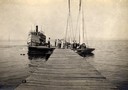
| Description: | Steamboat "Skater" and two sailboats at end of the mission dock on Madeline Island. |
| Date: | 1920 |
|---|---|
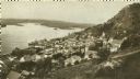
| Description: | Elevated view of Fountain City with the Mississippi River in the background. |

| Date: | 1910 |
|---|---|
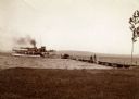
| Description: | Elevated view from hill of a steamer at Point Douglas going upstream on the Mississippi River. Caption reads: "Mississippi River at Prescott, Wis." |

| Date: | |
|---|---|
| Description: | Elevated view over trees toward a steamboat on the Mississippi River. Caption reads: "Mississippi River at Prescott, Wis." |
| Date: | |
|---|---|
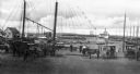
| Description: | A view toward a wharf with horse-drawn vehicles in the foreground, and a steamship in the distance. |
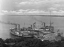
| Date: | 1910 |
|---|---|
| Description: | Elevated view of three steamships arriving at Fox's Dock, an island in Lake Erie. People are waiting on the docks. A smaller ship is in the dock area as we... |

| Date: | 1910 |
|---|---|
| Description: | View of tourists arriving on steamship. Many passengers are on the ship and the dock. |

| Date: | 1890 |
|---|---|
| Description: | Shows plat of town, local streets, steam boat landings, and Chippewa River. Public square and Muskoo Island hand-colored. Map reads: "Full Lots are 125x66 ... |

| Date: | 1831 |
|---|---|
| Description: | Map of the city of Louisville, Kentucky on the Ohio River showing streets and numbered lots. The Ohio River, Corn Island, and the Louisville and Portland C... |
If you didn't find the material you searched for, our Library Reference Staff can help.
Call our reference desk at 608-264-6535 or email us at: