 Filter: Categories of Wisconsin Historical Images
Filter: Subject of Islands
Filter: Subject of neighborhoods
Filter: Categories of Wisconsin Historical Images
Filter: Subject of Islands
Filter: Subject of neighborhoods
| Date: | |
|---|---|
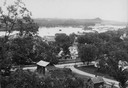
| Description: | View from hill looking down at houses and buildings at an intersection. Beyond are commercial buildings, the river, and the far shoreline. Hills are in the... |
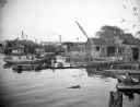
| Date: | 10 28 1938 |
|---|---|
| Description: | Docks and shanties at Jones Island, with smokestacks and cranes in the background. |
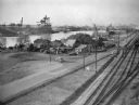
| Date: | 10 28 1938 |
|---|---|
| Description: | Elevated view of Jones Island, with some houses near the water and an industrial area across the river. On the right are a number of railroad tracks next t... |
| Date: | |
|---|---|
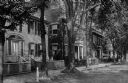
| Description: | Residences are shown on Main Street, exhibiting the colonial revival style. |
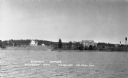
| Date: | 1937 |
|---|---|
| Description: | View from the lake of the summer homes on Nebraska Row along the shoreline of Lake Superior. The water tower and church steeple are visible on the far righ... |

| Date: | 1989 |
|---|---|
| Description: | This color coded map shows the various rivers, lakes, bays, and islands that make up the harbor. It includes an index of industries (maritime and non-marit... |
If you didn't find the material you searched for, our Library Reference Staff can help.
Call our reference desk at 608-264-6535 or email us at: