 Filter: Categories of Wisconsin Historical Images
Filter: Subject of Islands
Filter: Subject of mississippi river
Filter: Categories of Wisconsin Historical Images
Filter: Subject of Islands
Filter: Subject of mississippi river

| Date: | 1856 |
|---|---|
| Description: | This landscape painting by Samuel Marsden Brookes and Thomas H. Stevenson depicts a broad view of the confluence of Bad Axe and Mississippi Rivers; site of... |
| Date: | |
|---|---|
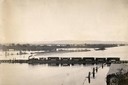
| Description: | Elevated view of the pile-pontoon railroad bridge across the Mississippi River at Prairie du Chien. The bridge was built and patented by John Lawler in 187... |

| Date: | |
|---|---|
| Description: | Two men posing on bluffs overlooking the Mississippi River at Fountain City. Fountain Brewery is visible at bottom right. |

| Date: | 1875 |
|---|---|
| Description: | Aerial view of Alma along Mississippi River, with bluffs along the horizon. |

| Date: | 1907 |
|---|---|
| Description: | Aerial view of the Mississippi River with log rafts. |
| Date: | 1920 |
|---|---|
| Description: | Elevated view of Fountain City with the Mississippi River in the background. |
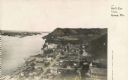
| Date: | 1925 |
|---|---|
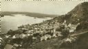
| Description: | Elevated view of Genoa. Caption reads: "Bird's Eye View, Genoa, Wis." The St. Charles Borromeo Catholic Church is in the right foreground. Railroad tracks ... |
| Date: | 1884 |
|---|---|
| Description: | Illustration of the Falls of St. Anthony, as seen in The Indian Tribes of the United States: their history antiquities, customs, religion, arts, languag... |
| Date: | 04 1862 |
|---|---|
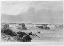
| Description: | Notes include: Sketch of Battle of Island #10. Sketch of Fort Pillow Tennessee. Gen. Pope had command of the land troops. |

| Date: | 1862 |
|---|---|
| Description: | An image from a sketchbook of "The Gunboats at No. 10 — Eve of Arrival before the I'sld". The drawing appears to be from the deck of a ship showing several... |

| Date: | 1955 |
|---|---|
| Description: | Aerial view of La Crosse, with Onalaska in the background. The highway is U.S. Highway 53 and the State Highway 35. |

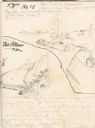
| Date: | 1820 |
|---|---|
| Description: | A manuscript map of Prairie du Chien. |

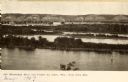
| Date: | 1910 |
|---|---|
| Description: | Elevated view from hill of a steamer at Point Douglas going upstream on the Mississippi River. Caption reads: "Mississippi River at Prescott, Wis." |

| Date: | 1910 |
|---|---|
| Description: | Wisconsin Geological and Natural History Survey, by Lawrence Martin reproduced from a model of the state prepared by W.O. Hotchkiss and F.T. Thwaites and m... |
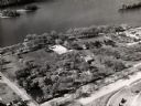
| Date: | 1960 |
|---|---|
| Description: | Aerial view of Villa Louis on the Mississippi River, and adjacent buildings. |
| Date: | 1905 |
|---|---|
| Description: | View looking toward old Diamond Jo Warehouse, before the bridge was built. Caption reads: "Mississippi River and Prairie du Chien, Wis., from Iowa Side". |
| Date: | 1910 |
|---|---|
| Description: | View from the bluffs in or near McGregor, Iowa. A fence and trees are in the foreground. |

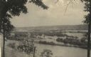
| Date: | |
|---|---|
| Description: | Elevated view over trees toward a steamboat on the Mississippi River. Caption reads: "Mississippi River at Prescott, Wis." |

| Date: | 1829 |
|---|---|
| Description: | Hand-colored lithograph of Fort Armstrong on Rock Island, based on a drawing by Henry Lewis. Foreground shows a tree floating in the water. |
If you didn't find the material you searched for, our Library Reference Staff can help.
Call our reference desk at 608-264-6535 or email us at:
