 Filter: Categories of Wisconsin Historical Images
Filter: Subject of Islands
Filter: Subject of log transportation
Filter: Categories of Wisconsin Historical Images
Filter: Subject of Islands
Filter: Subject of log transportation

| Date: | 1886 |
|---|---|
| Description: | Bird's-eye view of Ashland, on the shores of Lake Superior, with insets of The Apostle Islands Chequamagon Bay & Ashland, and Distances from Ashland. |

| Date: | 1870 |
|---|---|
| Description: | Bird's-eye map of Prairie du Sac. |

| Date: | 1874 |
|---|---|
| Description: | Bird's-eye map of Chippewa Falls. |

| Date: | 1872 |
|---|---|
| Description: | Birds-eye drawing of Eau Claire depicts street names and street locations, houses, trees, bridges, piers, canals, railroads, and the Chippewa and Eau Clair... |

| Date: | 1883 |
|---|---|
| Description: | Bird's-eye map of Prairie du Sac, Wisconsin with an inset of Clifton. |

| Date: | 1907 |
|---|---|
| Description: | Aerial view of the Mississippi River with log rafts. |
| Date: | 1900 |
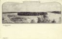
|---|---|
| Description: | Black and white elevated view of Half Moon Lake and Island. Logs are in a boom in the lake. Caption reads: "Half Moon Lake and Island," and "Eau Claire, Wi... |

| Date: | |
|---|---|
| Description: | Elevated view from bluff of Grand Rapids and the Wisconsin River. |
If you didn't find the material you searched for, our Library Reference Staff can help.
Call our reference desk at 608-264-6535 or email us at:
