 Filter: Categories of Wisconsin Historical Images
Filter: Subject of Islands
Filter: Subject of loading docks
Filter: Categories of Wisconsin Historical Images
Filter: Subject of Islands
Filter: Subject of loading docks

| Date: | 1755 |
|---|---|
| Description: | Map of Virginia and parts of Maryland, North Carolina, and New Jersey. It shows borders, boundary lines, some Native American land, counties, cities, towns... |
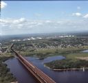
| Date: | 08 1971 |
|---|---|
| Description: | Aerial view of an ore dock next to Hog Island. The town is in the distance. In the far background are the white storage buildings of the oil refinery. |
If you didn't find the material you searched for, our Library Reference Staff can help.
Call our reference desk at 608-264-6535 or email us at: