Filter: Categories of Wisconsin Historical Images
Filter: Subject of Islands
Filter: Subject of industries
Filter: Categories of Wisconsin Historical Images
Filter: Subject of Islands
Filter: Subject of industries

| Date: | 1881 |
|---|---|
| Description: | Bird's-eye map of Marinette, with insets. |
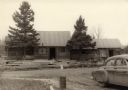
| Date: | 1956 |
|---|---|
| Description: | Constructing the Madeline Island Historical Museum in La Pointe which consists of four separate buildings. L-to-r: jail; American Fur Trade storage buildin... |

| Date: | 1886 |
|---|---|
| Description: | Bird's-eye view of Ashland, on the shores of Lake Superior, with insets of The Apostle Islands Chequamagon Bay & Ashland, and Distances from Ashland. |

| Date: | 1886 |
|---|---|
| Description: | Bird's-eye view of Bayfield, county seat of Bayfield County. On the lower left side is an inset for Bayfield and the Apostle Islands. |

| Date: | 1867 |
|---|---|
| Description: | Birds-eye drawing of Appleton, Outagamie Co., depicting street names and street layout, houses, the Fox River, the court house, jail, school houses, Lawren... |

| Date: | 1870 |
|---|---|
| Description: | Bird's-eye map of Prairie du Sac. |

| Date: | 1886 |
|---|---|
| Description: | Bird's-eye map of Washburn on Lake Superior. There is an inset of Washburn, Chequamagon and the Apostle Islands. |

| Date: | 1874 |
|---|---|
| Description: | Bird's-eye map of Chippewa Falls. |

| Date: | 1872 |
|---|---|
| Description: | Birds-eye drawing of Eau Claire depicts street names and street locations, houses, trees, bridges, piers, canals, railroads, and the Chippewa and Eau Clair... |

| Date: | 1883 |
|---|---|
| Description: | Bird's-eye map of Prairie du Sac, Wisconsin with an inset of Clifton. |

| Date: | 1879 |
|---|---|
| Description: | Bird's-eye map of Two Rivers. |

| Date: | 1910 |
|---|---|
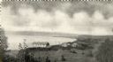
| Description: | Bird's-eye view looking east, with Washburn Harbor at center and Chequamegon Bay in Lake Superior covering most of the upper image. Streets with buildings... |
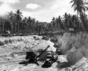
| Date: | 1944 |
|---|---|
| Description: | U.S. Marine Corps engineers excavating sand and rock with a steam shovel and a fleet of International trucks in the Pavuvu Islands. The International Harve... |
| Date: | 09 29 1963 |
|---|---|
| Description: | The Menasha Woodenware plant and water tower on Doty Island from across the Fox River canal, with a small railroad dolly in the foreground. |
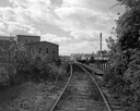
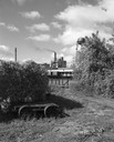
| Date: | 09 29 1963 |
|---|---|
| Description: | View down railroad tracks towards the railroad bridge, with industrial plants on Doty Island. |

| Date: | 1907 |
|---|---|
| Description: | Aerial view of the Mississippi River with log rafts. |
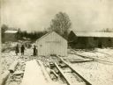
| Date: | |
|---|---|
| Description: | Snow-covered buildings of a fishing village on Rock Island (also known as Pottawatomie Island). |
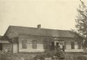
| Date: | 1922 |
|---|---|
| Description: | The American Fur Company warehouse, also called Old Treaty Hall. In 1832 the fur company moved its Bayfield post to the Island (Madeline Island), and on th... |
If you didn't find the material you searched for, our Library Reference Staff can help.
Call our reference desk at 608-264-6535 or email us at: