| Date: | 1939 |
|---|---|
| Description: | This map shows the towns to Gingles, Sanborn, and Guney as well as Chequamegon Bay, Kakagon River, White River, Marengo River, Bad River, Potato River, Vau... |

| Date: | 1882 |
|---|---|
| Description: | A hand-colored, sectional map of Wisconsin showing the township grid, completed and proposed railroads, counties, towns, cities, villages. The map also inc... |

| Date: | 1917 |
|---|---|
| Description: | This 1917 map of Ashland County, Wisconsin, shows the township and range system, towns, sections, cities and villages, the Bad River Indian Reservation, ra... |

| Date: | 1925 |
|---|---|
| Description: | This 1925 map of Ashland County, Wisconsin, shows the township and range system, towns, sections, cities and villages, the Bad River Indian Reservation, ra... |

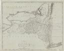
| Date: | 1795 |
|---|---|
| Description: | Detailed map of New York, showing counties, cities, mines, mills, roads, swamps, mountains, lakes and rivers. The map also shows Native American towns and ... |

| Date: | |
|---|---|
| Description: | A map of the Apostle Islands, including the harbor of Bayfield and its surroundings. |

| Date: | |
|---|---|
| Description: | Kodachrome postcard of an aerial view of Lac du Flambeau village and the surrounding chain of lakes. Caption reads: "Lac du Flambeau, Wisconsin." Text on b... |
If you didn't find the material you searched for, our Library Reference Staff can help.
Call our reference desk at 608-264-6535 or email us at: