 Filter: Categories of Wisconsin Historical Images
Filter: Subject of Islands
Filter: Subject of hills
Filter: Categories of Wisconsin Historical Images
Filter: Subject of Islands
Filter: Subject of hills

| Date: | 1856 |
|---|---|
| Description: | This landscape painting by Samuel Marsden Brookes and Thomas H. Stevenson depicts a broad view of the confluence of Bad Axe and Mississippi Rivers; site of... |
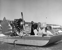
| Date: | 1954 |
|---|---|
| Description: | Elmer Nelson sorting through boxes of goods being transported on the "Dream Sled" windsled. |

| Date: | 1898 |
|---|---|
| Description: | Old Mission Residence at La Pointe, Madeline Island. |

| Date: | 1886 |
|---|---|
| Description: | Bird's-eye view of Bayfield, county seat of Bayfield County. On the lower left side is an inset for Bayfield and the Apostle Islands. |
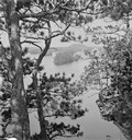
| Date: | |
|---|---|
| Description: | Elevated view through trees up the river towards islands, from the mouth of Witches' Gulch. |
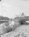
| Date: | |
|---|---|
| Description: | Looking upstream towards Blackhawk Island from opposite Ravine Bridge. There is a rowboat at the rocky shoreline. |
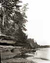
| Date: | |
|---|---|
| Description: | View along sandy shoreline towards Ink Stand and Sugar Bowl, south side. |

| Date: | 1886 |
|---|---|
| Description: | Bird's-eye map of Washburn on Lake Superior. There is an inset of Washburn, Chequamagon and the Apostle Islands. |

| Date: | 1872 |
|---|---|
| Description: | Birds-eye drawing of Eau Claire depicts street names and street locations, houses, trees, bridges, piers, canals, railroads, and the Chippewa and Eau Clair... |

| Date: | 1883 |
|---|---|
| Description: | Bird's-eye map of Prairie du Sac, Wisconsin with an inset of Clifton. |

| Date: | 1879 |
|---|---|
| Description: | Bird's-eye map of Two Rivers. |

| Date: | |
|---|---|
| Description: | Two men posing on bluffs overlooking the Mississippi River at Fountain City. Fountain Brewery is visible at bottom right. |

| Date: | 1875 |
|---|---|
| Description: | Aerial view of Alma along Mississippi River, with bluffs along the horizon. |

| Date: | 1907 |
|---|---|
| Description: | Aerial view of the Mississippi River with log rafts. |
| Date: | 1902 |
|---|---|
| Description: | One of several pyramid rock formations from which the lake takes its name. |
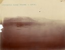
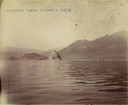
| Date: | 1902 |
|---|---|
| Description: | A distant view of Pyramid Lake's Rattlesnake Island. |
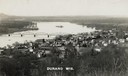
| Date: | 1910 |
|---|---|
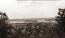
| Description: | Elevated view of Durand from a high vantage point, looking towards the river. A bridge spans the river, and in the foreground just below the hill is a chur... |
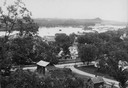
| Date: | |
|---|---|
| Description: | View from hill looking down at houses and buildings at an intersection. Beyond are commercial buildings, the river, and the far shoreline. Hills are in the... |
| Date: | |
|---|---|
| Description: | Elevated view of the residential section of Eau Claire from Mount Tom. |
If you didn't find the material you searched for, our Library Reference Staff can help.
Call our reference desk at 608-264-6535 or email us at:
