 Filter: Categories of Wisconsin Historical Images
Filter: Subject of Islands
Filter: Subject of ferries
Filter: Categories of Wisconsin Historical Images
Filter: Subject of Islands
Filter: Subject of ferries

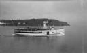
| Date: | 05 16 1973 |
|---|---|
| Description: | View of the ferry "Gar-How" taken from on board the ferry "Island Queen" while both were docked at Madeline Island. The "Gar-How" was named after Howard Ru... |

| Date: | |
|---|---|
| Description: | The screw ferry, "Wisconsin," docked at Washington Island. Twenty-one metal drums line the edge of the dock in the foreground. Original is in scrapbook on ... |

| Date: | 1929 |
|---|---|
| Description: | Ferryboat landing, with the boats providing service between Gills Rock and Washington Island. |

| Date: | 1969 |
|---|---|
| Description: | The Island's Edge, Williamsburg Bridge, East River. |

| Date: | 08 24 1964 |
|---|---|
| Description: | View from shoreline of two ferry boats in Lake Michigan. These two boats were once used as Mackinac Straits ferry boats and were later used as potato packi... |
| Date: | |
|---|---|
| Description: | View of the steamer ship "Islander" leaving Mackinac Island. Signs painted on the ship reads=: "Islander," "Arnold Line" and "St. Ignace Mackinac Island" (... |
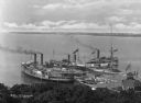
| Date: | 1910 |
|---|---|
| Description: | Elevated view of three steamships arriving at Fox's Dock, an island in Lake Erie. People are waiting on the docks. A smaller ship is in the dock area as we... |

| Date: | 1910 |
|---|---|
| Description: | View of tourists arriving on steamship. Many passengers are on the ship and the dock. |

| Date: | 1940 |
|---|---|
| Description: | This tourist map of Door County, Wisconsin, lists the points of interest and tourist hotels, cabins and cottages in the area. Ferry schedules to Washington... |

| Date: | 05 01 1899 |
|---|---|
| Description: | Map showing the Schuylkill River with roads, ferries, and points of interest from Valley Forge to Philadelphia, Pennsylvania as it appeared during the Revo... |

| Date: | 11 1781 |
|---|---|
| Description: | Map of New York, Staten Island, and Long Island, showing the placements of forts, and the movement of troops in 1776. The map also includes towns, cities, ... |

| Date: | 1795 |
|---|---|
| Description: | Map of South Carolina showing the precincts, cities, towns, Native American villages (marked with a triangle), courthouses, roads, mountains, swamps, islan... |
If you didn't find the material you searched for, our Library Reference Staff can help.
Call our reference desk at 608-264-6535 or email us at: