 Filter: Categories of Wisconsin Historical Images
Filter: Subject of Islands
Filter: Subject of disasters
Filter: Categories of Wisconsin Historical Images
Filter: Subject of Islands
Filter: Subject of disasters
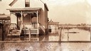
| Date: | 1918 |
|---|---|
| Description: | House surrounded by high water on Madeline Island. |

| Date: | |
|---|---|
| Description: | Map of the district of the Peshtigo fire, approximately 1,280,000 acres, in Wisconsin and Upper Michigan. |
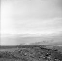
| Date: | 1945 |
|---|---|
| Description: | Elevated view of marines Private Richard Klatt, of North Fond du Lac, Wisconsin (left), and Private First Class Wilfred Voegeli, as they set fire to brush ... |
| Date: | |
|---|---|
| Description: | Etching of the "Attack upon Roanoke Island" by troops landing from naval vessels, after a painting by Chappel. |

| Date: | 1916 |
|---|---|
| Description: | This version of a 1916 Wisconsin Conservation Commission map shows Peninsula State Park in the Town of Gibraltar, Door County, Wisconsin. Depicted are open... |
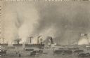
| Date: | 08 31 1944 |
|---|---|
| Description: | Smoke rising from Cezembre Island, just north of Saint-Malo on the north coast of France. The island, which took a tremendous shelling, can barely be seen ... |

| Date: | 1746 |
|---|---|
| Description: | Detailed map of the western hemisphere and part of Africa and Europe. Islands, cities, settlements, rivers, lakes, countries, and regions are marked. Mount... |
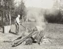
| Date: | 1908 |
|---|---|
| Description: | Wearing gloves, I.P. Rumsey is holding a stick and tending a smoking fire outdoors in a clearing on the Island. Archibald Lake is in the background. |
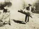
| Date: | 1908 |
|---|---|
| Description: | Looking at the camera, Albert Rhode, possibly a lumberjack, is standing and holding a big, heavy log. He is wearing a long sleeved shirt, pants, and a hat.... |
If you didn't find the material you searched for, our Library Reference Staff can help.
Call our reference desk at 608-264-6535 or email us at: