 Filter: Categories of Wisconsin Historical Images
Filter: Subject of Islands
Filter: Subject of dams
Filter: Categories of Wisconsin Historical Images
Filter: Subject of Islands
Filter: Subject of dams

| Date: | 1872 |
|---|---|
| Description: | Birds-eye drawing of Eau Claire depicts street names and street locations, houses, trees, bridges, piers, canals, railroads, and the Chippewa and Eau Clair... |

| Date: | 1905 |
|---|---|
| Description: | View from shoreline towards a river with a dam in the distance. Caption reads: "River Scene, Mayville, Wis." |

| Date: | 1828 |
|---|---|
| Description: | Map of the Louisville and Portland Canal on the Ohio River. The map shows Louisville, Shippingsport, Clarksville, Jeffersonville, Gravel Island, Corn Islan... |

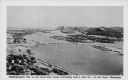
| Date: | 03 11 1937 |
|---|---|
| Description: | Elevated, panoramic view of the Chickamauga Dam. |

| Date: | 09 14 1938 |
|---|---|
| Description: | Aerial, panoramic view towards the Chickamauga Dam. |

| Date: | 02 09 1939 |
|---|---|
| Description: | Aerial, panoramic view from downstream towards the Chickamauga Dam. |

| Date: | 09 14 1922 |
|---|---|
| Description: | Text on front reads: "On the Wisconsin." Wooded islands on the Wisconsin River as seen from the shore. The opposite shoreline is in the background. The pow... |
| Date: | 1936 |
|---|---|
| Description: | Text on front reads: "Trempealeau Wis. on the Great River Road overlooking Lock & Dam No. 6 on the Upper Mississippi." On reverse: "Lock & Dam No. 6, one o... |
If you didn't find the material you searched for, our Library Reference Staff can help.
Call our reference desk at 608-264-6535 or email us at: