 Filter: Categories of Wisconsin Historical Images
Filter: Subject of Islands
Filter: Subject of birds
Filter: Categories of Wisconsin Historical Images
Filter: Subject of Islands
Filter: Subject of birds

| Date: | 1856 |
|---|---|
| Description: | This landscape painting by Samuel Marsden Brookes and Thomas H. Stevenson depicts a broad view of the confluence of Bad Axe and Mississippi Rivers; site of... |

| Date: | 1856 |
|---|---|
| Description: | While passing through the English Channel in May 1856 Hölzlhuber viewed the Isle of Wight. "The island is located in the English Channel not far from Hamps... |
| Date: | 1884 |
|---|---|
| Description: | Illustration of the Falls of St. Anthony, as seen in The Indian Tribes of the United States: their history antiquities, customs, religion, arts, languag... |
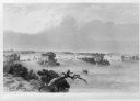
| Date: | 07 1923 |
|---|---|
| Description: | Members of the photographer's family shield their heads with their clothing while walking among grassy hummocks on Gravelly Island. There are many seagulls... |

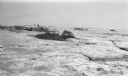
| Date: | 1964 |
|---|---|
| Description: | Docks at Jones Island with a lone swan swimming. Many large ships and city buildings can be seen in the background. |

| Date: | 1696 |
|---|---|
| Description: | Engraved and hand-colored map of Ethiopia, from Blaeu's General Atlas. Map title is framed by a man and a woman, both wearing head turbans, who are standin... |
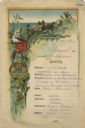
| Date: | 08 09 1890 |
|---|---|
| Description: | One-page menu from the R.M.S.S. Magdalena of the Royal Mail Steam Packet Company, with a parrot and a cockatiel perched on a branch above the compan... |

| Date: | |
|---|---|
| Description: | Illustration of Fort Armstrong on Rock Island, looking from opposite shoreline. There is a barge and other boats on the Mississippi River in front of the f... |
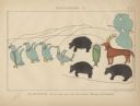
| Date: | 1851 |
|---|---|
| Description: | Pictograph E., Plate 63, "Kaizheosh, and his Band from Lake Vieu Desert. Michigan and Wisconsin." A group of symbols including birds, animals, a fish and a... |

| Date: | 1685 |
|---|---|
| Description: | A detailed map of the western hemisphere showing cities, settlements, Native American land, rivers, lakes, mountains, the Great Lakes, and California as an... |

| Date: | 1746 |
|---|---|
| Description: | Detailed map of the western hemisphere and part of Africa and Europe. Islands, cities, settlements, rivers, lakes, countries, and regions are marked. Mount... |

| Date: | 1719 |
|---|---|
| Description: | Map of North America showing land divisions between France, Spain, England, Sweden, Denmark and Holland. The map is detailed, labeling cities, forts, islan... |
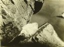
| Date: | 1910 |
|---|---|
| Description: | A young bird in a rock crevice on Rocky Island. The island is on Rainy Lake. |

| Date: | 1898 |
|---|---|
| Description: | Annie McClure is holding Jeannette Holt while looking at a bird's nest in a tree. Archibald Lake is in the background. Caption reads: "A Birds Nest — Annie... |

| Date: | 1931 |
|---|---|
| Description: | Peter DeWitt and a friend or cousin are sitting on the sand beach near logs. A bird is perched nearby on a wooden pier. |
If you didn't find the material you searched for, our Library Reference Staff can help.
Call our reference desk at 608-264-6535 or email us at: