 Filter: Categories of Wisconsin Historical Images
Filter: Subject of Islands
Filter: County of Door
Filter: Categories of Wisconsin Historical Images
Filter: Subject of Islands
Filter: County of Door

| Date: | 1941 |
|---|---|
| Description: | Elevated view of Sturgeon Bay in 1900. Sturgeon Bay Bridge spans the bay and several boats are on the water. A lighthouse sits on a small island in the bay... |

| Date: | |
|---|---|
| Description: | Aerial view of Potawatomi State Park, with the Sturgeon Bay shoreline in the background. |

| Date: | 1920 |
|---|---|
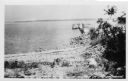
| Description: | View from beach across Spike Horn Bay towards Cana Island and the Cana Island Light. |

| Date: | 1900 |
|---|---|
| Description: | This blue line print map shows land use, cables, U.S.L.S.S. walk and clearing, and front and rear range lights on the Porte des Morts Passage. Tree types a... |

| Date: | 1959 |
|---|---|
| Description: | This map includes directories, illustrations, and an inset location map and also covers Rock, Hog, Detroit and Plum islands. |

| Date: | 1936 |
|---|---|
| Description: | This map shows campsites, trails, auto roads, surrounding townships, and points of interest, by including pictorial illustrations. Includes an inserted map... |
| Date: | |
|---|---|
| Description: | View from shoreline towards a boat docked at a pier at Death's Door, with Plum Island in the distance. |
| Date: | |
|---|---|
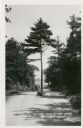
| Description: | View down a road, with a tree growing in the center. Lake Michigan and Plum Island are in the distance. |
| Date: | |
|---|---|
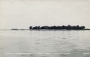
| Description: | View across water towards Little Strawberry Island in Green Bay. The beach on the left side of the island is sandy, and a house can be seen among the trees... |

| Date: | |
|---|---|
| Description: | Elevated view of Green Bay from Ephraim. There is an island in the bay. Caption reads: "Lake View from Scandinavian Peasant Craft Shop, Ephraim, Wis." |

| Date: | |
|---|---|
| Description: | Drawing of a map showing the cruise routes from Eagle Inn Dock and the points of interest. There is a schedule and rates on the reverse. |
| Date: | |
|---|---|
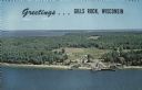
| Description: | A color aerial view of Gills Rock from Green Bay. Washington Island and Lake Michigan are along the horizon. An excursion boat is docked at the landing. Ca... |

| Date: | 1940 |
|---|---|
| Description: | A young woman smiles as she enjoys the view from the Potawatomi Tower in Potawatomi State Park. There is a house on a small island in Sawyer Harbor, with ... |
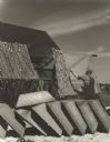
| Date: | 07 1951 |
|---|---|
| Description: | A man preparing nets wound on large reels for fishing. A row of tubs are in the foreground and a shed is in the background. |
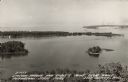
| Date: | 1940 |
|---|---|
| Description: | Text on front reads: "Sawyer Harbor and Cabot's Point from Tower, Potowatomi State Park, Door County, Wis." Elevated view across Sawyer Harbor towards Stur... |
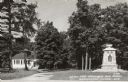
| Date: | 1940 |
|---|---|
| Description: | Text on front reads: "World War Memorial and School, Washington Island, Wis." The school is on the left and the memorial is on the right, among trees. |
If you didn't find the material you searched for, our Library Reference Staff can help.
Call our reference desk at 608-264-6535 or email us at: