Filter: Categories of Wisconsin Historical Images
Filter: Subject of Islands
Filter: Type of Photograph
Filter: Subject of water
Filter: Categories of Wisconsin Historical Images
Filter: Subject of Islands
Filter: Type of Photograph
Filter: Subject of water

| Date: | 1878 |
|---|---|
| Description: | View down Rock River towards a covered bridge near another bridge, with factories and the city in the background. |
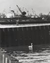
| Date: | 1964 |
|---|---|
| Description: | Docks at Jones Island with a lone swan swimming. Many large ships and city buildings can be seen in the background. |
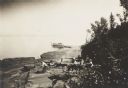
| Date: | 1912 |
|---|---|
| Description: | Picnic party on the rocks along the shore, among the Apostle Islands in Lake Superior. |

| Date: | |
|---|---|
| Description: | Aerial view of Potawatomi State Park, with the Sturgeon Bay shoreline in the background. |
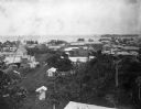
| Date: | 1902 |
|---|---|
| Description: | Elevated view of the city of Port Limon, Costa Rica with the Caribbean Sea in the background. Trees grow amongst the many commercial and residential buildi... |

| Date: | 1920 |
|---|---|
| Description: | View from beach across Spike Horn Bay towards Cana Island and the Cana Island Light. |

| Date: | 1910 |
|---|---|
| Description: | Doctor Thorne was one of the members of Carrie's travel party. He is pictured here, in front of Victoria Falls on Livingstone Island. |

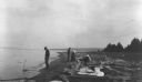
| Date: | 1915 |
|---|---|
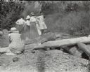
| Description: | View looking towards shoreline of three men and one woman setting up a fire on the rocks for a picnic. There is a picnic basket on the log on the right, an... |
| Date: | |
|---|---|
| Description: | Group of people at a picnic on the shoreline at Bass Island. Names written on back of print: Mrs. Abernathy, chair; Mrs. Hull; Mrs. Baker. |
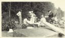
| Date: | 08 22 1916 |
|---|---|
| Description: | View along shoreline towards people at a Bear Island picnic. A man stands near the water, and two women and a another man are among the logs along the shor... |

| Date: | |
|---|---|
| Description: | View across water towards Governor's Island and its exposed cliff at the shoreline with trees and plants growing on top. Governor’s Island, formerly part o... |

| Date: | 01 07 1894 |
|---|---|
| Description: | Winter view of early buildings on Rocky Roost, which was west of Governor's Island. There is snow on the roofs, on the rocks and on the shore of Lake Mendo... |

| Date: | |
|---|---|
| Description: | View from shoreline of a lake. Trees and plants are in the foreground, and across the water may be islands as well as the far shoreline, which are tree-cov... |

| Date: | |
|---|---|
| Description: | View from shoreline over a marshy area towards a lake at Northern Lakes Park. There is a tree-covered shoreline in the far background. There may be an isl... |

| Date: | 1929 |
|---|---|
| Description: | Aerial view of Lake Namakagon, showing the roads that connect Anderson Island (center left), and Juneks Point, Eagle Point, and Paines Island. |

| Date: | 1907 |
|---|---|
| Description: | Hand-colored view across water towards three islands in big Cedar Lake. The center island has a resort building with a red roof. |

| Date: | |
|---|---|
| Description: | Elevated view overlooking a large lake. There appears to be a small island off the lakeshore. |

| Date: | 1675 |
|---|---|
| Description: | Map of the southeast coast of North America from Jamestown to modern Georgia. It shows European settlements, Native American land and villages, coastal fea... |

| Date: | 1914 |
|---|---|
| Description: | A view across the water towards Five Mile Rock, a large rock formation off the north shore of Lake Superior. |
If you didn't find the material you searched for, our Library Reference Staff can help.
Call our reference desk at 608-264-6535 or email us at: