 Filter: Categories of Wisconsin Historical Images
Filter: Subject of Islands
Filter: Type of Photograph
Filter: Subject of roads
Filter: Categories of Wisconsin Historical Images
Filter: Subject of Islands
Filter: Type of Photograph
Filter: Subject of roads
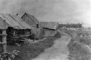
| Date: | 1897 |
|---|---|
| Description: | Dirt trail passing log shack that was probably the home of Michael and Madeline Cadotte. |
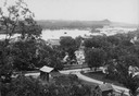
| Date: | |
|---|---|
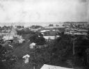
| Description: | View from hill looking down at houses and buildings at an intersection. Beyond are commercial buildings, the river, and the far shoreline. Hills are in the... |

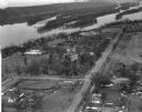
| Date: | 1956 |
|---|---|
| Description: | Aerial view looking northeast from a point over the east end of Middleton, showing the west end of Lake Mendota (right mid-ground). Fox Bluff juts into the... |
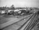
| Date: | 10 28 1938 |
|---|---|
| Description: | Elevated view of Jones Island, with some houses near the water and an industrial area across the river. On the right are a number of railroad tracks next t... |
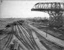
| Date: | 10 28 1938 |
|---|---|
| Description: | Elevated view of railroad yard and railroads cars on Jones Island. On the right is a large derrick or crane, and in the background are a number of freighte... |
| Date: | 03 28 1949 |
|---|---|
| Description: | Aerial view of Prairie du Chien showing the Mississippi River in the background. |

| Date: | 08 24 1964 |
|---|---|
| Description: | Tree-lined entrance to the D.S. Funk property, which is visible through the trees. Two rustic fences and a lamppost flank the driveway. A sign hanging abov... |

| Date: | 08 24 1964 |
|---|---|
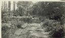
| Description: | View of a forest interior as seen from West Harbor Road. A large variety of vegetation grows within the forest. |

| Date: | |
|---|---|
| Description: | A view looking down a dirt road, surrounded by large trees and smaller palm trees. |
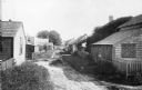
| Date: | 1898 |
|---|---|
| Description: | View across road of Syl standing in front of a three-story duplex house on Jones Island. |

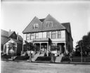
| Date: | |
|---|---|
| Description: | Residences are shown on Main Street, exhibiting the colonial revival style. |
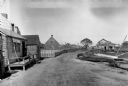
| Date: | |
|---|---|
| Description: | A view along the backs of cottages on a village lane in Siaconset, Nantucket Island. Shrubs line the unpaved road, and fences demarcate each cottage's yard... |

| Date: | |
|---|---|
| Description: | Bird's eye view of Coney Island featuring the amusement park, shoreline, river, and a large boat. |
| Date: | |
|---|---|
| Description: | General view of town streets, with a harbor and early American store exteriors. |
| Date: | |
|---|---|
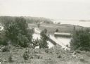
| Description: | Elevated view overlooking a road leading toward water, a boathouse, cabins, and a lake, most likely Jackson Lake. The shoreline on the far top right is ide... |

| Date: | |
|---|---|
| Description: | View of wagons and carriages lined up on a road on Concordia Island for a picnic. |

| Date: | |
|---|---|
| Description: | Aerial view of Potawatomi State Park, with the Sturgeon Bay shoreline in the background. |
| Date: | 1902 |
|---|---|
| Description: | Elevated view of the city of Port Limon, Costa Rica with the Caribbean Sea in the background. Trees grow amongst the many commercial and residential buildi... |
| Date: | |
|---|---|
| Description: | Main Road to the back of Hull Cottage on Madeline Island. |

| Date: | 1929 |
|---|---|
| Description: | Aerial view of Lake Namakagon, showing the roads that connect Anderson Island (center left), and Juneks Point, Eagle Point, and Paines Island. |
If you didn't find the material you searched for, our Library Reference Staff can help.
Call our reference desk at 608-264-6535 or email us at: