 Filter: Categories of Wisconsin Historical Images
Filter: Subject of Islands
Filter: Type of Photograph
Filter: Subject of forests and forestry
Filter: Categories of Wisconsin Historical Images
Filter: Subject of Islands
Filter: Type of Photograph
Filter: Subject of forests and forestry

| Date: | 07 10 1949 |
|---|---|
| Description: | Aerial view of Minocqua showing the surrounding lakes. |
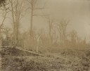
| Date: | 1898 |
|---|---|
| Description: | A forest from the Ojibwa-Pillager Battle at Sugar Point on Bear Island. |

| Date: | 1902 |
|---|---|
| Description: | River with distant hills behind a town. An island is in the foreground. |
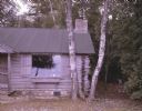
| Date: | 08 22 1964 |
|---|---|
| Description: | A close view of Jack Myers' log cabin on Washington Island. The cabin is surrounded by thick woods. |
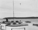
| Date: | 08 20 1964 |
|---|---|
| Description: | View over fishing boat of Rock Island, as seen from Jackson Harbor. |

| Date: | |
|---|---|
| Description: | Park with stone-lined waterways, surrounded by woods. In the middle of the image is a small island with a rustic stone hut and in the background are stone... |

| Date: | |
|---|---|
| Description: | View of a dirt road, cleared land, Jackson Lake and shoreline. Off to the far right is where the Nature Lovers Paradise resort cottages were located. A sig... |

| Date: | 1930 |
|---|---|
| Description: | Aerial view of the northern tip of the Door Peninsula, looking north. Europe Lake is in the center, with Europe Bay to the right. Plum Island and Washingto... |

| Date: | 1930 |
|---|---|
| Description: | Aerial view looking northeast, with Rowley's Bay in the foreground. Europe Lake is to the left, with Europe Bay and Newport Bay separated by a narrow peni... |

| Date: | 1930 |
|---|---|
| Description: | Aerial view over northern Door County, looking northeast across Europe Lake and Europe Bay toward Plum and Washington Islands. Farm fields and orchards con... |

| Date: | 1930 |
|---|---|
| Description: | Aerial view from over Moonlight Bay, looking east across Bues Point to Spike Horn Bay and Cana Island. The Cana Island Lighthouse is seen as a ship passes ... |

| Date: | 1930 |
|---|---|
| Description: | Aerial view, looking north, across the beach and pier on Europe Bay to Europe Lake and beyond to Washington Island. The land south (to the right) of Europe... |

| Date: | 1929 |
|---|---|
| Description: | View from entrance of a cave looking out to the Mississippi River, a railroad bridge, all surrounded by a forest. There is a small island in the river. |

| Date: | 1929 |
|---|---|
| Description: | Elevated view from Signal Point of the Mississippi River, railroad and surrounding forest and wetlands. |
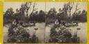
| Date: | 1860 |
|---|---|
| Description: | Two men and two women visit sit on a small, rocky island or natural bridge near water. Plants and trees are on shoreline behind them. |

| Date: | 1929 |
|---|---|
| Description: | Aerial view of Lake Namakagon, showing the roads that connect Anderson Island (center left), and Juneks Point, Eagle Point, and Paines Island. |

| Date: | 1675 |
|---|---|
| Description: | Map of the southeast coast of North America from Jamestown to modern Georgia. It shows European settlements, Native American land and villages, coastal fea... |
| Date: | 1911 |
|---|---|
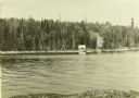
| Description: | A view across Pickerel Lake of The Gang's camp on an island. There is a tent set up and smoke is wafting up from a campfire. |
| Date: | 1911 |
|---|---|
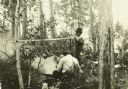
| Description: | Two Canadian Rangers eating a meal by the campfire at their camp on Eden Island by Quetico Lake. |
If you didn't find the material you searched for, our Library Reference Staff can help.
Call our reference desk at 608-264-6535 or email us at:
