 Filter: Categories of Wisconsin Historical Images
Filter: Subject of Industrial buildings
Filter: County of Sauk
Filter: Subject of industries
Filter: Categories of Wisconsin Historical Images
Filter: Subject of Industrial buildings
Filter: County of Sauk
Filter: Subject of industries
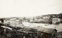
| Date: | 1868 |
|---|---|
| Description: | View of the Baraboo River and surrounding structures. |
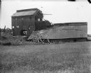
| Date: | 1909 |
|---|---|
| Description: | A deteriorating mining building seen from across a field. |
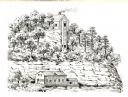
| Date: | 1836 |
|---|---|
| Description: | The shot tower at Tower Hill State Park. |
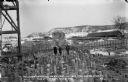
| Date: | 03 03 1912 |
|---|---|
| Description: | Two women and a man posing among the timber pilings near the east shore of the river. Wooden concrete forms and two buildings are in the background. |
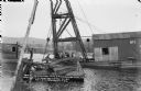
| Date: | 05 03 1912 |
|---|---|
| Description: | Workmen on a barge using a pulley to raise sheet steel pilings which were damaged by high water in October, 1911. |
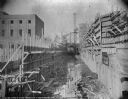
| Date: | 05 28 1913 |
|---|---|
| Description: | Workmen on temporary walkways among reinforcing bars on the roof of the power house. |
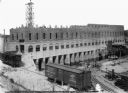
| Date: | 09 01 1913 |
|---|---|
| Description: | Elevated view of the power house from the southwest showing progress of the brickwork. Two railroad cars are standing on the railroad extension. Workers ar... |
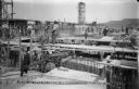
| Date: | 11 01 1913 |
|---|---|
| Description: | Wooden forms are in place for construction of the walls of the lock at the Prairie du Sac dam. The newly constructed power house is on the left. |
| Date: | 03 24 1938 |
|---|---|
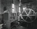
| Description: | Interior view of the municipal water plant pump house showing the auxiliary and emergency pump units, powered by an International P-30 power unit. |
| Date: | 09 19 1961 |
|---|---|
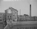
| Description: | View of a woolen mill, as seen from across a river and dam. |
| Date: | 05 20 1962 |
|---|---|
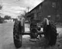
| Description: | A parked tractor on a street near industrial buildings. |
| Date: | 1925 |
|---|---|
| Description: | Elevated view of Main Street, with industrial and commercial buildings. Cars are parked at the curb towards the far end of the street, and fields and tree-... |

| Date: | 1909 |
|---|---|
| Description: | Elevated view of the Baraboo River. The main part of town is on the far left shoreline. On the right industrial buildings are near a bridge spanning the ri... |
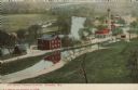
| Date: | 1908 |
|---|---|
| Description: | Colorized postcard with an elevated view of the pumping station. On the left is a bridge over the river, and buildings on a strip of land between the river... |

| Date: | 07 1870 |
|---|---|
| Description: | This map of Ironton is pen-and-ink on paper and shows lots and block numbers, mill, foundry buildings, limestone quarry, iron mine, and roads. Relief is sh... |
If you didn't find the material you searched for, our Library Reference Staff can help.
Call our reference desk at 608-264-6535 or email us at:
