 Filter: Categories of Wisconsin Historical Images
Filter: Subject of Indians of North America
Filter: Subject of fishing
Filter: Categories of Wisconsin Historical Images
Filter: Subject of Indians of North America
Filter: Subject of fishing

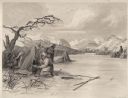
| Date: | 1842 |
|---|---|
| Description: | This hand-colored lithograph of the second Fort Howard, with Indians canoeing on the Fox River, shows the hospital built 1834-1835 outside the stockade on ... |
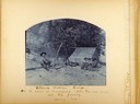
| Date: | 1889 |
|---|---|
| Description: | Beach fishing camp showing several people around a fire drying fish with a tent in the background. Captioned: Ottawa Fishing Camp -- On the Island at Fran... |
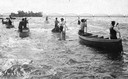
| Date: | 07 16 1898 |
|---|---|
| Description: | A group of Ojibwa men fishing from boats. |
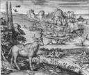
| Date: | 1655 |
|---|---|
| Description: | Scene near Jamestown Settlement in Virginia, ca. 1614. |
| Date: | 1923 |
|---|---|
| Description: | The original caption reads: "A Hupa youth is waiting with poised spear for the shadowy outline of a salmon lurking in a quiet pool and gathering its streng... |

| Date: | 1930 |
|---|---|
| Description: | Pictorial map of Glacier National Park, Montana and Waterton Lakes National Park, Alberta. Illustrated by Joe Scheurle, it depicts white people, American ... |

| Date: | 1957 |
|---|---|
| Description: | Large Letter style postcard for Green Bay depicting various scenes in the letters that spell the name of the city. Caption reads: "Greetings from Green Bay... |

| Date: | 1939 |
|---|---|
| Description: | This map shows the towns to Gingles, Sanborn, and Guney as well as Chequamegon Bay, Kakagon River, White River, Marengo River, Bad River, Potato River, Vau... |
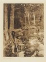
| Date: | 1884 |
|---|---|
| Description: | Small group of Native Americans spearing fish through ice on a river. Mountains can be seen in the background. |

| Date: | 1895 |
|---|---|
| Description: | This late 19th century map of northern Wisconsin and a portion of Michigan's Upper Peninsula shows the township and range grid, the (Lac du) Flambeau India... |

| Date: | 1994 |
|---|---|
| Description: | This map shows historical sites, picnic grounds, public boat landings, canoe and motor boat trips, and resort locations. The left margin of the map include... |

| Date: | 1720 |
|---|---|
| Description: | One of Herman Moll's most famous maps, often referred to as The Beaver Map for its elaborate engraved inset depicting and describing beavers building a dam... |

| Date: | 1750 |
|---|---|
| Description: | Map of the northeast corner of America and Canada with hand-colored boundaries. The map shows colonies, Native American nations, fishing areas, and detaile... |

| Date: | 1759 |
|---|---|
| Description: | Map of north eastern Canada and parts of New England, showing settlements, cities, portages, Native American land, mountains, lakes, and rivers. The unusua... |

| Date: | 1783 |
|---|---|
| Description: | Map of the newly formed United States showing borders, regions, Native American land, cities, mountains, lakes, and rivers. It includes a small inset map o... |

| Date: | 02 04 1783 |
|---|---|
| Description: | One of the first and few maps to attempt to map the new boundaries of the United States and British territories during the preliminary treaty at the end of... |

| Date: | 1972 |
|---|---|
| Description: | This colored map displays Wisconsin and bordering areas of Iowa, Minnesota, and Michigan. There is color-coding on the map to indicate National Forests, an... |

| Date: | 1971 |
|---|---|
| Description: | This colored map displays Wisconsin and bordering areas of Iowa, Minnesota, and Michigan. There is color-coding on the map to indicate National Forests, an... |

| Date: | 1973 |
|---|---|
| Description: | This colored map displays Wisconsin and bordering areas of Iowa, Minnesota, and Michigan. There is color-coding on the map to indicate National Forests, a... |

| Date: | 1962 |
|---|---|
| Description: | This colored map represents "Tour #2" of a series of driving tours of the state published by the Sperry & Hutchinson Company, in order to "help you enjoy W... |
If you didn't find the material you searched for, our Library Reference Staff can help.
Call our reference desk at 608-264-6535 or email us at: