 Filter: Categories of Wisconsin Historical Images
Filter: Subject of Indians of North America
Filter: County of Ashland
Filter: Year of 1800-1899
Filter: Categories of Wisconsin Historical Images
Filter: Subject of Indians of North America
Filter: County of Ashland
Filter: Year of 1800-1899
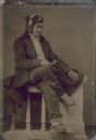
| Date: | 1891 |
|---|---|
| Description: | Tintype (ferrotype) portrait of Shadomo, or Dirty Pelican, a Chippewa (Ojibwa) from the Odanah Reservation near Ashland. |

| Date: | 1890 |
|---|---|
| Description: | Stereograph of Presbyterian Mission school grounds in the Chippewa Indian reservation. Building in background, boy walking in field in foreground. |

| Date: | 1890 |
|---|---|
| Description: | Stereograph of Presbyterian Mission school. People gathered in front of building. Fence in foreground of photograph. |

| Date: | 1885 |
|---|---|
| Description: | Stereograph. Probably the Presbyterian Mission School grounds on the Chippewa Indian reservation. Two boys and a dog are standing in the foreground, with a... |
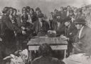
| Date: | 1870 |
|---|---|
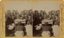
| Description: | Indians receiving payment. Seated on the right is John W. Bell. Others are, left to right, Asaph Whittlesey, Agent Henry C. Gilbert, and William S. Warren ... |
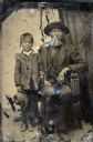
| Date: | 1854 |
|---|---|
| Description: | Tintype of Michael De Perry and unidentified child. |
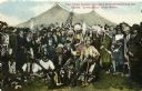
| Date: | 1896 |
|---|---|
| Description: | Colored postcard view of "Buffalo Bill" Cody center right in white coat and hat surrounded by Native Americans in traditional garb, military personnel and ... |

| Date: | 1887 |
|---|---|
| Description: | This 1887 map of Ashland County, Wisconsin, shows the township and range system, sections, railroads, vacant Wisconsin Central Railroad land, state and "go... |

| Date: | 1896 |
|---|---|
| Description: | This 1898 map shows the township and range system, sections, cities and villages, railroads, roads, vacant land and land sold by the Wisconsin Central Rail... |

| Date: | 1890 |
|---|---|
| Description: | This map shows the Wisconsin Central Railroad land grant lands owned and for sale by the Soo Line in Ashland County, Wisconsin, as well as in portions of B... |

| Date: | 1886 |
|---|---|
| Description: | This map of Ashland County, Wisconsin, which at the time included part of present-day Iron County, also covers portions of Vilas County, Wisconsin, then pa... |

| Date: | 1890 |
|---|---|
| Description: | This 1890s map shows the Wisconsin Central Railroad land grant lands owned and for sale by the Soo Line in Ashland County, Wisconsin, as well as in the eas... |

| Date: | 1898 |
|---|---|
| Description: | This 1898 map of Ashland County, Wisconsin, shows the township and range grid, towns, sections, cities and villages, landownership, roads, railroads, swamp... |
| Date: | 1852 |
|---|---|
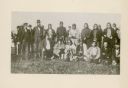
| Description: | Group portrait of members of the La Pointe Band (now known as the Bad River La Pointe Band) of the Ojibwe Nation awaiting annuity payment at La Pointe. Non... |

| Date: | 1866 |
|---|---|
| Description: | Stereograph of an Ojibwa woman sitting on an overturned canoe with a baby on her back wrapped in a blanket. A young child is sitting at her feet. They are ... |
| Date: | 1870 |
|---|---|
| Description: | Ojibwa Indians receiving annuity payment. Seated on the right is John W. Bell. Others are, left to right, Asaph Whittlesey, Agent Henry C. Gilbert, and Wil... |
If you didn't find the material you searched for, our Library Reference Staff can help.
Call our reference desk at 608-264-6535 or email us at: