 Filter: Categories of Wisconsin Historical Images
Filter: Subject of Indian reservations
Filter: Year of 1900-1999
Filter: Year of 1970-1979
Filter: Categories of Wisconsin Historical Images
Filter: Subject of Indian reservations
Filter: Year of 1900-1999
Filter: Year of 1970-1979

| Date: | 1974 |
|---|---|
| Description: | This 1968 map identifies resorts in the Lac du Flambeau Indian Reservation region of Wisconsin, covering parts of Iron, Vilas, Oneida, and Price counties. ... |
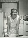
| Date: | 11 26 1970 |
|---|---|
| Description: | A candid portrait of Olivia King in her kitchen at their home on Rabbit Ridge on the Menominee reservation. |

| Date: | 1975 |
|---|---|
| Description: | This map shows boundaries, roads, national forest land, bogs and wetlands, lakes, campgrounds, and boat landings. |

| Date: | 1974 |
|---|---|
| Description: | This map draws content from a map originally created by George Featherstongaugh in 1840. The map shows streets, land ownership, the Brotherton Indian reser... |

| Date: | 1977 |
|---|---|
| Description: | Frances Decorah and her son Patrick at a Pow-wow in South Dakota. She is seated in a lawn chair and Patrick is napping on her lap. Frances is wearing stree... |

| Date: | 1972 |
|---|---|
| Description: | This colored map displays Wisconsin and bordering areas of Iowa, Minnesota, and Michigan. There is color-coding on the map to indicate National Forests, an... |

| Date: | 1971 |
|---|---|
| Description: | This colored map displays Wisconsin and bordering areas of Iowa, Minnesota, and Michigan. There is color-coding on the map to indicate National Forests, an... |

| Date: | 1973 |
|---|---|
| Description: | This colored map displays Wisconsin and bordering areas of Iowa, Minnesota, and Michigan. There is color-coding on the map to indicate National Forests, a... |
If you didn't find the material you searched for, our Library Reference Staff can help.
Call our reference desk at 608-264-6535 or email us at:

