 Filter: Categories of Wisconsin Historical Images
Filter: Subject of Indian reservations
Filter: Year of 1900-1999
Filter: Year of 1920-1929
Filter: Categories of Wisconsin Historical Images
Filter: Subject of Indian reservations
Filter: Year of 1900-1999
Filter: Year of 1920-1929
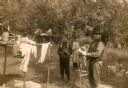
| Date: | 1925 |
|---|---|
| Description: | Native American settlement. This photograph is thought to represent a view of the Chippewa (Ojibwa) settlement at Lac du Flameau. Probably photographed by ... |
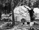
| Date: | 1929 |
|---|---|
| Description: | Wisconsin Dells, Wisconsin, circa 1929. Camp ground at Indian Hill Pageant near Highway 13. |
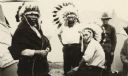
| Date: | 1922 |
|---|---|
| Description: | Wisconsin Winnebago on a Menominee Reservation wearing Sioux war head dress. |
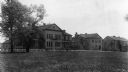
| Date: | 1929 |
|---|---|
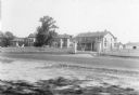
| Description: | The Government Indian School in Keshena. |
| Date: | 1929 |
|---|---|
| Description: | The U.S. Department of the Interior, Keshena Indian School. |

| Date: | 1922 |
|---|---|
| Description: | A map of Iron County, Wisconsin, shows sections and the towns of Upson, Hurley, Hamilton, Saxon, and Mercer, lakes and streams, villages, railroads, roads ... |

| Date: | 1920 |
|---|---|
| Description: | This map of Sawyer County, Wisconsin, from the early 20th century shows the township and range system, towns, sections, cities and villages, railroads, hig... |

| Date: | 1925 |
|---|---|
| Description: | This 1925 map of Ashland County, Wisconsin, shows the township and range system, towns, sections, cities and villages, the Bad River Indian Reservation, ra... |
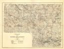
| Date: | 1929 |
|---|---|
| Description: | Map of the Menominee Indian Reservation. Legend reads: "Topographic and cultural data were obtained from field notes of a timber cruise and land classifica... |
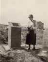
| Date: | 1926 |
|---|---|
| Description: | A woman holding flowers is standing between two graves, looking at the one on the left. Caption reads: "Wind River Indian Reservation (formerly the Shosho... |
If you didn't find the material you searched for, our Library Reference Staff can help.
Call our reference desk at 608-264-6535 or email us at: