 Filter: Categories of Wisconsin Historical Images
Filter: Subject of Indian reservations
Filter: Subject of water
Filter: Categories of Wisconsin Historical Images
Filter: Subject of Indian reservations
Filter: Subject of water

| Date: | 1936 |
|---|---|
| Description: | This map is red and black ink on tracing cloth and is oriented with north to the upper left. This hand-drawn map shows a central portion of the military ro... |

| Date: | 1886 |
|---|---|
| Description: | This map shows U.S. land offices, completed railroads, railroad land grant limits, lakes, rivers, and Indian reservations. Communities, lakes, and rivers a... |

| Date: | 1910 |
|---|---|
| Description: | Sawmill on a Menominee Indian reservation, with logs floating in the water in the foreground. Caption reads: "Menominee Indian Mills." |
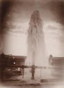
| Date: | |
|---|---|
| Description: | Water gushes 18 feet in the air from a 6-inch pipe at the Lower Brule Agency. A man stands behind the pipe on the right. |
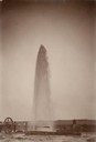
| Date: | |
|---|---|
| Description: | Water gushes 60 feet in the air from a 4-inch pipe at the Lower Brule Agency. Two men stand on the left near pumping machinery. |

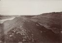
| Date: | |
|---|---|
| Description: | The Metolas river runs through the reservation at the Warm Springs Agency in Oregon. |
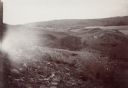
| Date: | |
|---|---|
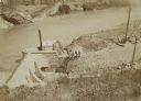
| Description: | The Fort Smith Bluffs at the Big Horn Ditch on the Crow Reservation in northeast Wyoming. |
| Date: | |
|---|---|
| Description: | The Fort Smith Bluffs at the Big Horn Ditch on the Crow Reservation in northeast Wyoming. |
| Date: | |
|---|---|
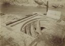
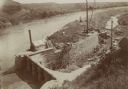
| Description: | The head gate at the Big Horn Ditch on the Crow Reservation in northeast Wyoming. Men are working with cranes near a tent with a chimney spewing out smoke. |
| Date: | |
|---|---|
| Description: | The head gate at the Big Horn Ditch on the Crow Reservation in northeast Wyoming. |
| Date: | |
|---|---|
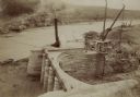
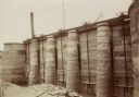
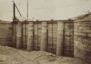
| Description: | Retaining walls at the head gate of the Big Horn Ditch on the Crow Reservation in northeast Wyoming. |
| Date: | |
|---|---|
| Description: | A front view of the head gate of the Big Horn Ditch on the Crow Reservation in northeast Wyoming. |
| Date: | |
|---|---|
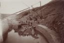
| Description: | The head gate of the Big Horn Ditch on the Crow Reservation in northeast Wyoming. |
| Date: | |
|---|---|
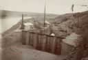
| Description: | The head gate of the Big Horn Ditch on the Crow Reservation in northeast Wyoming. |
| Date: | |
|---|---|
| Description: | The head gate of the Big Horn Ditch on the Crow Reservation in northeast Wyoming. |
| Date: | |
|---|---|
| Description: | A front view of the head gate of the Big Horn Ditch on the Crow Reservation in northeast Wyoming. |
| Date: | |
|---|---|
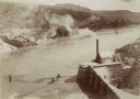
| Description: | A front view of the Big Horn Ditch on the Crow Reservation in northeast Wyoming. |
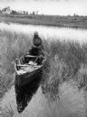
| Date: | 1941 |
|---|---|
| Description: | Joe Stoddard of the Chippewa tribe harvesting wild rice on the Bad River Indian Reservation. |
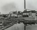
| Date: | 1950 |
|---|---|
| Description: | A sawmill run on the Menominee Indian Reservation. |
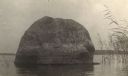
| Date: | 1905 |
|---|---|
| Description: | Rock near the principal village of the Chippewa Indian Reservation. |
If you didn't find the material you searched for, our Library Reference Staff can help.
Call our reference desk at 608-264-6535 or email us at: