 Filter: Categories of Wisconsin Historical Images
Filter: Subject of Indian reservations
Filter: Subject of rivers
Filter: Creator Name of Unknown
Filter: Categories of Wisconsin Historical Images
Filter: Subject of Indian reservations
Filter: Subject of rivers
Filter: Creator Name of Unknown

| Date: | |
|---|---|
| Description: | The Metolas river runs through the reservation at the Warm Springs Agency in Oregon. |
| Date: | |
|---|---|
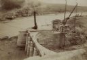
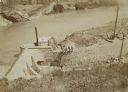
| Description: | The head gate at the Big Horn Ditch on the Crow Reservation in northeast Wyoming. Men are working with cranes near a tent with a chimney spewing out smoke. |
| Date: | |
|---|---|
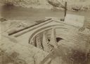
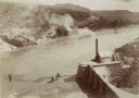
| Description: | The head gate at the Big Horn Ditch on the Crow Reservation in northeast Wyoming. |
| Date: | |
|---|---|
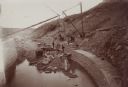
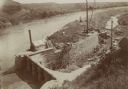
| Description: | Retaining walls at the head gate of the Big Horn Ditch on the Crow Reservation in northeast Wyoming. |
| Date: | |
|---|---|
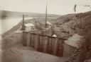
| Description: | A front view of the head gate of the Big Horn Ditch on the Crow Reservation in northeast Wyoming. |
| Date: | |
|---|---|
| Description: | The head gate of the Big Horn Ditch on the Crow Reservation in northeast Wyoming. |
| Date: | |
|---|---|
| Description: | The head gate of the Big Horn Ditch on the Crow Reservation in northeast Wyoming. |
| Date: | |
|---|---|
| Description: | The head gate of the Big Horn Ditch on the Crow Reservation in northeast Wyoming. |

| Date: | 1877 |
|---|---|
| Description: | Map showing location of Indian reservations in the United States and population figures. |
| Date: | |
|---|---|
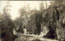
| Description: | Postcard of Route 55 Menominee Indian reservation, Dells of Wolf River. |

| Date: | 1900 |
|---|---|
| Description: | A map of Wisconsin, eastern Minnesota and Iowa, northern Iowa, and Michigan’s Upper Peninsula, showing railway lines, with those marked with heavy red line... |

| Date: | 1871 |
|---|---|
| Description: | The township grid in the counties bordering Lake Superior in northern Wisconsin and Minnesota is shown. Rivers, lakes, Indian reservations, and the rail li... |

| Date: | 1898 |
|---|---|
| Description: | This 1898 map of Sawyer County, Wisconsin, shows the township and range system, sections, roads, farm houses, camps, school houses, dams, bridges, Indian r... |

| Date: | 1900 |
|---|---|
| Description: | This map of Sawyer County, Wisconsin, shows the numbered "sub-school-districts of the town of Hayward" school houses, and the Indian reservation. The towns... |

| Date: | 1910 |
|---|---|
| Description: | This map shows the locations of school houses, farms, roads, railroads, and Bad River Indian Reservation. Relief is shown by hachures. Yellow and red manus... |

| Date: | 1790 |
|---|---|
| Description: | This map of the north eastern states shows roads, rivers, lakes, waterfalls, mountains, cities, forts, mills, the Oneida Reservation, and "New York Donatio... |

| Date: | |
|---|---|
| Description: | A map of the Apostle Islands, including the harbor of Bayfield and its surroundings. |

| Date: | 1854 |
|---|---|
| Description: | A sketch of the public surveys of Wisconsin and territory of Minnesota. |
If you didn't find the material you searched for, our Library Reference Staff can help.
Call our reference desk at 608-264-6535 or email us at: