 Filter: Categories of Wisconsin Historical Images
Filter: Subject of Indian reservations
Filter: Subject of human settlements
Filter: Year of 1900-1999
Filter: Categories of Wisconsin Historical Images
Filter: Subject of Indian reservations
Filter: Subject of human settlements
Filter: Year of 1900-1999

| Date: | 1936 |
|---|---|
| Description: | This map is red and black ink on tracing cloth and is oriented with north to the upper left. This hand-drawn map shows a central portion of the military ro... |

| Date: | 1910 |
|---|---|
| Description: | Sawmill on a Menominee Indian reservation, with logs floating in the water in the foreground. Caption reads: "Menominee Indian Mills." |
| Date: | 1956 |
|---|---|
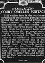
| Description: | Historical marker of the Namekagon Portage on the Lac Court Oreilles Native American Reservation. |
| Date: | 1929 |
|---|---|
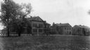
| Description: | The Government Indian School in Keshena. |
| Date: | 1929 |
|---|---|
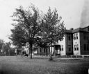
| Description: | The U.S. Department of the Interior, Keshena Indian School. |
| Date: | 1936 |
|---|---|
| Description: | St. Joseph's Indian School on the Keshena Menominee Reservation. |

| Date: | 1935 |
|---|---|
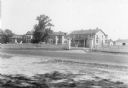
| Description: | Menominee Indian Reservation Government School near Shawano. Caption reads: "Government School, Menominee Indian Reservation, Near Shawano, Wis." |
| Date: | 1935 |
|---|---|
| Description: | U.S. Department of the Indian agency building on the Menominee Indian Reservation. |
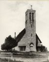
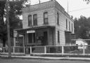
| Date: | 1900 |
|---|---|
| Description: | Hobart Episcopal Church on the Oneida Indian Reservation. |
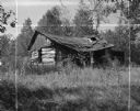
| Date: | 09 17 1961 |
|---|---|
| Description: | A broken down, abandoned log shack on the Stockbridge Indian Reservation. |

| Date: | 1900 |
|---|---|
| Description: | A map of Wisconsin, eastern Minnesota and Iowa, northern Iowa, and Michigan’s Upper Peninsula, showing railway lines, with those marked with heavy red line... |

| Date: | 1931 |
|---|---|
| Description: | This U.S. Geological Survey map of Wisconsin shows counties, cities and villages, lighthouses, Indian reservations, military reservations, and bird and gam... |

| Date: | 1941 |
|---|---|
| Description: | Wisconsin counties, towns, cities, and selected villages, as well as the Menominee Indian Reservation are identified on this U.S. Bureau of the Census map ... |

| Date: | 1944 |
|---|---|
| Description: | This nine-part map from the U.S. Bureau of Public Roads identifies federal and state highways in Wisconsin by pavement type. County, forest, park, and publ... |

| Date: | 1950 |
|---|---|
| Description: | This road map shows federal, state and county roads in Wisconsin, northern Illinois, northeastern Iowa, eastern Minnesota, and the western portion of Michi... |

| Date: | 1902 |
|---|---|
| Description: | This map shows the railroads of southern Wisconsin with the routes of the Chicago, Milwaukee, and St. Paul Railway traced in red. The township grid, counti... |

| Date: | 1910 |
|---|---|
| Description: | This map of northeastern Wisconsin shows the township grid, counties, cities and villages, lakes, rivers, rail lines and the Menominee Indian Reservation. ... |

| Date: | 1912 |
|---|---|
| Description: | This map from the U.S. General Land Office shows railroads, counties, cities and villages, rivers, lakes, U.S. Land Offices, Indian reservations, military ... |

| Date: | 1922 |
|---|---|
| Description: | A map of Iron County, Wisconsin, shows sections and the towns of Upson, Hurley, Hamilton, Saxon, and Mercer, lakes and streams, villages, railroads, roads ... |

| Date: | 1932 |
|---|---|
| Description: | A map of Iron County, Wisconsin, shows towns and sections, lakes and streams, villages, railroads, roads, and La Point and Lac Du Flambeau Indian reservati... |
If you didn't find the material you searched for, our Library Reference Staff can help.
Call our reference desk at 608-264-6535 or email us at: