 Filter: Categories of Wisconsin Historical Images
Filter: Subject of Indian reservations
Filter: Subject of human settlements
Filter: Year of 1900-1999
Filter: Year of 1950-1959
Filter: Categories of Wisconsin Historical Images
Filter: Subject of Indian reservations
Filter: Subject of human settlements
Filter: Year of 1900-1999
Filter: Year of 1950-1959
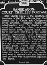
| Date: | 1956 |
|---|---|
| Description: | Historical marker of the Namekagon Portage on the Lac Court Oreilles Native American Reservation. |

| Date: | 1950 |
|---|---|
| Description: | This road map shows federal, state and county roads in Wisconsin, northern Illinois, northeastern Iowa, eastern Minnesota, and the western portion of Michi... |

| Date: | 1956 |
|---|---|
| Description: | This map shows reservation boundaries, U.S. township lines, highways, roads, rivers, and lakes. The lower left corner of the map includes a legend of "Conv... |
If you didn't find the material you searched for, our Library Reference Staff can help.
Call our reference desk at 608-264-6535 or email us at: