 Filter: Categories of Wisconsin Historical Images
Filter: Subject of Indian reservations
Filter: Subject of human settlements
Filter: Creator Name of Unknown
Filter: Categories of Wisconsin Historical Images
Filter: Subject of Indian reservations
Filter: Subject of human settlements
Filter: Creator Name of Unknown
| Date: | |
|---|---|
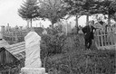
| Description: | Man posing by a gate in the Red Cliff Indian Reservation cemetery. |
| Date: | 1956 |
|---|---|
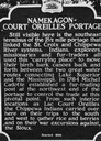
| Description: | Historical marker of the Namekagon Portage on the Lac Court Oreilles Native American Reservation. |

| Date: | 1897 |
|---|---|
| Description: | This 1897 map of Sawyer County, Wisconsin, shows the township and range system, sections, roads, farm houses, camps, school houses, dams, bridges, Indian r... |

| Date: | 1902 |
|---|---|
| Description: | This 1902 map of the eastern portion of Sawyer County, Wisconsin, shows the township and range system, sections, roads, farm houses, camps, school houses, ... |

| Date: | 1890 |
|---|---|
| Description: | This 1890s map shows the Wisconsin Central Railroad land grant lands owned and for sale by the Soo Line in Ashland County, Wisconsin, as well as in the eas... |

| Date: | 1909 |
|---|---|
| Description: | This map shows vacant Wisconsin Central Ry. lands, settlers houses, lands sold by Wisconsin Central Ry., schools, churches, saw mills, and roads; also show... |
If you didn't find the material you searched for, our Library Reference Staff can help.
Call our reference desk at 608-264-6535 or email us at: