 Filter: Categories of Wisconsin Historical Images
Filter: Subject of Indian reservations
Filter: Subject of architecture
Filter: Categories of Wisconsin Historical Images
Filter: Subject of Indian reservations
Filter: Subject of architecture
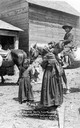
| Date: | 1909 |
|---|---|
| Description: | A group of four Native American children thought to have been photographed at the Menominee Reservation. This image is part of an exhibit about Native Amer... |

| Date: | 1909 |
|---|---|
| Description: | A Menominee child, probably photographed on the reservation near Keshena and Neopit, Wisconsin. He is standing outside in front of a log cabin, and an axe ... |

| Date: | 1953 |
|---|---|
| Description: | Color photograph of young Native-American men dressed in traditional clothing standing around an International R-Line truck. The young men are with a small... |
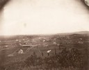
| Date: | |
|---|---|
| Description: | Men walk on a hill at a Creek Nation Reservation, in Sapulpa, Indian Territory. |
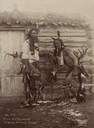
| Date: | |
|---|---|
| Description: | Omaha Sioux Dancers at the Rosebud Agency. The two men are standing in front of a log cabin with a sod roof and wooden door. |
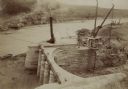
| Date: | |
|---|---|
| Description: | The head gate at the Big Horn Ditch on the Crow Reservation in northeast Wyoming. Men are working with cranes near a tent with a chimney spewing out smoke. |
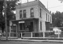
| Date: | 1935 |
|---|---|
| Description: | U.S. Department of the Indian agency building on the Menominee Indian Reservation. |
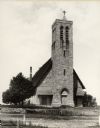
| Date: | 1900 |
|---|---|
| Description: | Hobart Episcopal Church on the Oneida Indian Reservation. |

| Date: | 07 1959 |
|---|---|
| Description: | Governor Gaylord Nelson signing the bill which created Menominee County as the state's 72nd county. The new county consisted of those portions of Shawano a... |
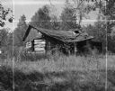
| Date: | 09 17 1961 |
|---|---|
| Description: | A broken down, abandoned log shack on the Stockbridge Indian Reservation. |

| Date: | 1896 |
|---|---|
| Description: | This hand-colored map shows counties, county seats, cities, towns, proposed and completed railroads, and U.S. Land Offices. Also included in the map are th... |

| Date: | 1880 |
|---|---|
| Description: | A hand-colored map of the Chippewa, Price, Taylor and the northern part of Clark counties, which shows the locations of farmhouses, schoolhouses, churches,... |

| Date: | 1931 |
|---|---|
| Description: | This U.S. Geological Survey map of Wisconsin shows counties, cities and villages, lighthouses, Indian reservations, military reservations, and bird and gam... |

| Date: | 1912 |
|---|---|
| Description: | This map from the U.S. General Land Office shows railroads, counties, cities and villages, rivers, lakes, U.S. Land Offices, Indian reservations, military ... |

| Date: | 1896 |
|---|---|
| Description: | A map of Iron County, Wisconsin, shows vacant Wisconsin Central Rail Road lands, settlers houses, land sold by Wisconsin Central R.R., schools, churches, s... |

| Date: | 1898 |
|---|---|
| Description: | A map of Iron County, Wisconsin, shows vacant Wisconsin Central Rail Road lands, settlers houses, land sold by Wisconsin Central R.R., schools, churches, s... |

| Date: | |
|---|---|
| Description: | A map that shows the Wisconsin Central Railway land grant lands for sale by the Soo Line, the Chicago, Milwaukee, and St. Paul Railway. Town sections, lak... |

| Date: | 1897 |
|---|---|
| Description: | This 1897 map of Sawyer County, Wisconsin, shows the township and range system, sections, roads, farm houses, camps, school houses, dams, bridges, Indian r... |

| Date: | 1898 |
|---|---|
| Description: | This 1898 map of Sawyer County, Wisconsin, shows the township and range system, sections, roads, farm houses, camps, school houses, dams, bridges, Indian r... |

| Date: | 1900 |
|---|---|
| Description: | This 1900 map shows the township and range system, sections, cities and villages, railroads, roads, vacant land and land sold by the Wisconsin Central Rail... |
If you didn't find the material you searched for, our Library Reference Staff can help.
Call our reference desk at 608-264-6535 or email us at: