 Filter: Categories of Wisconsin Historical Images
Filter: Subject of Indian reservations
Filter: County of Bayfield
Filter: Categories of Wisconsin Historical Images
Filter: Subject of Indian reservations
Filter: County of Bayfield

| Date: | 07 04 1913 |
|---|---|
| Description: | Indian "Powwow" and Lacrosse contest between various Indian reservations. |
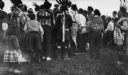
| Date: | 1913 |
|---|---|
| Description: | Powwow at the Red Cliff Indian Reservation on the shores of Lake Superior. |
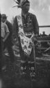
| Date: | 1913 |
|---|---|
| Description: | Native American at a Red Cliff Indian Reservation Powwow on the shores of Lake Superior. |

| Date: | 1900 |
|---|---|
| Description: | This 1900 map shows the township and range system, sections, cities and villages, railroads, roads, vacant land and land sold by the Wisconsin Central Rail... |

| Date: | 1935 |
|---|---|
| Description: | This topographical map of the forest preserve shows highways, roads, trails, telephone lines, Native American reservations, Ranger sub-stations, state nurs... |

| Date: | 1912 |
|---|---|
| Description: | This map shows a school reserve, swamp land, railroads, and selected buildings. |

| Date: | 2000 |
|---|---|
| Description: | This map shows national parks, county and state forests, Indian reservations, municipal land, private land, docks, boat access, camping, and points of inte... |
If you didn't find the material you searched for, our Library Reference Staff can help.
Call our reference desk at 608-264-6535 or email us at: