 Filter: Categories of Wisconsin Historical Images
Filter: Subject of Indian reservations
Filter: Creator Name of Wisconsin. Conservation Department.
Filter: Categories of Wisconsin Historical Images
Filter: Subject of Indian reservations
Filter: Creator Name of Wisconsin. Conservation Department.
| Date: | |
|---|---|
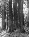
| Description: | White pines on the Menominee Reservation. A man is standing next to the trees on the left-hand side of the image. |

| Date: | 06 1934 |
|---|---|
| Description: | This Wisconsin Conservation Department map shows national, state, and county forests both approved and pending, as well as Indian reservations in Wisconsin... |

| Date: | 1937 |
|---|---|
| Description: | This map shows the Wisconsin Conservation Department forest protection divisions and the locations of state forests, national forests, Indian reservations,... |

| Date: | 1937 |
|---|---|
| Description: | This Wisconsin Conservation Department map shows the locations of state forests, national forests, county forests, state nurseries, Indian reservations, st... |

| Date: | 05 01 1938 |
|---|---|
| Description: | This map shows the locations of Wisconsin Conservation Department forest protection districts and cooperative areas, state forests, national forests, India... |

| Date: | 1950 |
|---|---|
| Description: | A young woman is posing sitting on a boulder on the shoreline along a river rapids. She is holding a walking stick and is wearing a romper. The description... |
| Date: | 1940 |
|---|---|
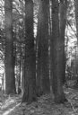
| Description: | Lear Shewano is dwarfed by a grove of huge virgin white pine trees in the Menominee Indian Reservation. He is wearing a white hat and plaid shirt. |
If you didn't find the material you searched for, our Library Reference Staff can help.
Call our reference desk at 608-264-6535 or email us at: