 Filter: Categories of Wisconsin Historical Images
Filter: Subject of Hunting
Filter: Subject of streams
Filter: Categories of Wisconsin Historical Images
Filter: Subject of Hunting
Filter: Subject of streams
| Date: | |
|---|---|
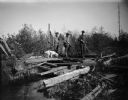
| Description: | Three men with firearms cross a stream with a dog following. |

| Date: | 1935 |
|---|---|
| Description: | This pictorial map of northern Bayfield County, Wisconsin, shows the Chequamegon National Forest, the Red Cliff Indian Reservation, highways and roads, and... |

| Date: | 1895 |
|---|---|
| Description: | This late 19th century map of northern Wisconsin and a portion of Michigan's Upper Peninsula shows the township and range grid, the (Lac du) Flambeau India... |

| Date: | 1986 |
|---|---|
| Description: | This late 1980s map of Price County, Wisconsin, shows facilities and lands open for public recreation, hunter walking trails and ski trails, campgrounds, b... |
| Date: | |
|---|---|
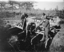
| Description: | Four young men standing on a wooden platform over a stream, shooting rifles down into the water. Probably shooting fish. A dog is standing behind the group... |
| Date: | |
|---|---|
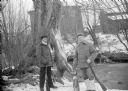
| Description: | Exterior portrait of two hunters posing with a deer carcass, a fox carcass and rifles on the edge of a stream in winter. Buildings are in the background. |
If you didn't find the material you searched for, our Library Reference Staff can help.
Call our reference desk at 608-264-6535 or email us at: