Filter: Categories of Wisconsin Historical Images
Filter: Subject of Hunting
Filter: Subject of rivers
Filter: Categories of Wisconsin Historical Images
Filter: Subject of Hunting
Filter: Subject of rivers

| Date: | 1821 |
|---|---|
| Description: | Indians of the North Red River area, probably in the vicinity of old Fort Douglas, now Winnipeg, Canada, spearing beaver. |

| Date: | 1867 |
|---|---|
| Description: | Bird's-eye map of Green Bay and Fort Howard, Brown Co., depicts street names and street layouts, houses, trees, and the East River. A reference key at the ... |

| Date: | 1870 |
|---|---|
| Description: | Bird's-eye view of Whitewater, with insets. |

| Date: | 1930 |
|---|---|
| Description: | An original lithograph promoting Kentucky and the Pennsylvania Railroad through an artist's depiction of two men dressed in buckskin, wearing raccoon hats ... |
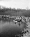
| Date: | |
|---|---|
| Description: | A hunter, sporting cold weather attire and thigh-high rubber boots, pulls a mink in a trap off the shoreline and on to his small, motorized, fishing boat. ... |
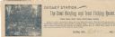
| Date: | |
|---|---|
| Description: | Letterhead of Dudley Station, a hunting and trout fishing resort in Dudley, Wisconsin. On the left is an illustration of a fisherman holding a fishing pole... |

| Date: | 1903 |
|---|---|
| Description: | A map of northern Wisconsin and Michigan showing the names and locations hunting and fishing resorts in the area, as well as location of Chicago and North ... |

| Date: | 1914 |
|---|---|
| Description: | Two maps of northern Wisconsin counties of Ashland, Barron, Bayfield, Chippewa, Douglas, Forest, Iron, Langlade, Lincoln, Oneida, Polk, Price, Sawyer, Tayl... |
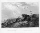
| Date: | |
|---|---|
| Description: | Elevated view of two men sitting on the side of a rock formation. The man on the right is holding a rifle and a stringer of squirrels. The man on the left ... |
| Date: | 1948 |
|---|---|
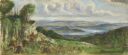
| Description: | Prior to the 1948 State Fair, artist Robert Hodgell traveled Wisconsin to study its many landscapes. He then produced a series of study sketches outlining ... |

| Date: | 1991 |
|---|---|
| Description: | This 1991 map of Burnett County, Wisconsin, shows Governor Knowles State Forest, wildlife areas, public hunting grounds, and other outdoor recreation facil... |

| Date: | 1905 |
|---|---|
| Description: | This pictorial representation of part of Lake Winnebago and the Fox River in 1703, showing interactions between white beaver hunters and the Iroquois is ta... |

| Date: | 1976 |
|---|---|
| Description: | Panel title. Shows railroads, roads, highways, boundaries, dams, public hunting and fishing grounds, cemeteries, forest ranger stations, plant life, and s... |
| Date: | 1888 |
|---|---|
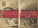
| Description: | Front and back cover of catalog, featuring on the front an illustration of birds, mice, and flying insects near a wheat field. The back cover reads: "Manuf... |

| Date: | 1910 |
|---|---|
| Description: | Group of twelve men and one boy posing on a dock. A dog lays at the feet of the man in the center. Three of the men hold stringers of dead ducks. On the fa... |

| Date: | 1910 |
|---|---|
| Description: | Two hunters pose in a wooded area. Their kill, two deer, hang upside down from a wooden beam supported by branches of trees. The deer have what appear to b... |

| Date: | 1891 |
|---|---|
| Description: | This map shows soft marshland, water channels, solid ground, club boundary and shooting boxes. Big Lake, First Channel, Second Channel, Fout Mile Pond, Mal... |

| Date: | 1891 |
|---|---|
| Description: | This map shows soft marshland, water channels, solid ground, club boundary and shooting boxes. Big Lake, First Channel, Second Channel, Fout Mile Pond, Mal... |

| Date: | 1959 |
|---|---|
| Description: | This map shows public access sites, public beaches and parks, other public shorelines, boat liveries, public hunting and fishing grounds, railroads, roads,... |
If you didn't find the material you searched for, our Library Reference Staff can help.
Call our reference desk at 608-264-6535 or email us at: