 Filter: Categories of Wisconsin Historical Images
Filter: Subject of Hunting
Filter: Subject of lakes
Filter: Categories of Wisconsin Historical Images
Filter: Subject of Hunting
Filter: Subject of lakes
| Date: | |
|---|---|
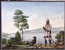
| Description: | Watercolor of Canadian Prairie Indian at lake's shore with gun in hand and a recently hunted duck on the ground. A dog is at his feet. On the far shoreline... |

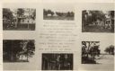
| Date: | 1870 |
|---|---|
| Description: | Bird's-eye view of Whitewater, with insets. |
| Date: | |
|---|---|
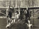
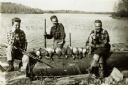
| Description: | Two men standing on a pontoon airplane with their dog and a line of ducks they successfully hunted. |
| Date: | 1913 |
|---|---|
| Description: | Photographic mock-up for an Alfred Stanley Johnson photomontage postcard entitled "Kickers." A boy wearing waders and holding a rifle stands with his arms ... |
| Date: | |
|---|---|
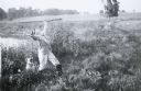
| Description: | A duck hunter at the edge of a rocky shoreline, probably Sigurd Olson. |
| Date: | |
|---|---|
| Description: | Sigurd Olson with his sons, Robert and Sig Jr., after a duck hunt. |
| Date: | 07 02 1925 |
|---|---|
| Description: | Photographic postcard of a poster promoting Camp Milo on White Sand Lake. On it are photographs of the cabins, tents, lake, and boats on the shore. |

| Date: | 1903 |
|---|---|
| Description: | A map of northern Wisconsin and Michigan showing the names and locations hunting and fishing resorts in the area, as well as location of Chicago and North ... |

| Date: | 1914 |
|---|---|
| Description: | Two maps of northern Wisconsin counties of Ashland, Barron, Bayfield, Chippewa, Douglas, Forest, Iron, Langlade, Lincoln, Oneida, Polk, Price, Sawyer, Tayl... |

| Date: | 1935 |
|---|---|
| Description: | This pictorial map of northern Bayfield County, Wisconsin, shows the Chequamegon National Forest, the Red Cliff Indian Reservation, highways and roads, and... |

| Date: | 1991 |
|---|---|
| Description: | This 1991 map of Burnett County, Wisconsin, shows Governor Knowles State Forest, wildlife areas, public hunting grounds, and other outdoor recreation facil... |

| Date: | 1905 |
|---|---|
| Description: | This pictorial representation of part of Lake Winnebago and the Fox River in 1703, showing interactions between white beaver hunters and the Iroquois is ta... |

| Date: | 1895 |
|---|---|
| Description: | This late 19th century map of northern Wisconsin and a portion of Michigan's Upper Peninsula shows the township and range grid, the (Lac du) Flambeau India... |

| Date: | 1986 |
|---|---|
| Description: | This late 1980s map of Price County, Wisconsin, shows facilities and lands open for public recreation, hunter walking trails and ski trails, campgrounds, b... |

| Date: | 1910 |
|---|---|
| Description: | Two hunters pose in a wooded area. Their kill, two deer, hang upside down from a wooden beam supported by branches of trees. The deer have what appear to b... |

| Date: | 1910 |
|---|---|
| Description: | This map shows counties, roads, Lake Superior, Lake Michigan, and portions of surrounding states. Also included is a list of railroads showing miles and gr... |

| Date: | 1918 |
|---|---|
| Description: | Manuscript map of the Chequamegon Bay area on Lake Superior drawn by Warren W. Witmer and illustrated with sketches by Mary L. Wright Witmer in ink and wat... |

| Date: | 1891 |
|---|---|
| Description: | This map shows soft marshland, water channels, solid ground, club boundary and shooting boxes. Big Lake, First Channel, Second Channel, Fout Mile Pond, Mal... |

| Date: | 1959 |
|---|---|
| Description: | This map shows public access sites, public beaches and parks, other public shorelines, boat liveries, public hunting and fishing grounds, railroads, roads,... |
If you didn't find the material you searched for, our Library Reference Staff can help.
Call our reference desk at 608-264-6535 or email us at:
