 Filter: Categories of Wisconsin Historical Images
Filter: Subject of Hunting
Filter: Subject of hotels
Filter: Categories of Wisconsin Historical Images
Filter: Subject of Hunting
Filter: Subject of hotels

| Date: | 1867 |
|---|---|
| Description: | Bird's-eye map of Green Bay and Fort Howard, Brown Co., depicts street names and street layouts, houses, trees, and the East River. A reference key at the ... |

| Date: | |
|---|---|
| Description: | Deer and a variety of other game are strung from a tree in a hunting camp at Hotel Alphin. An open tent stands to the right. |
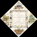
| Date: | 10 02 1884 |
|---|---|
| Description: | Foldout menu with a central menu listing, with a banner at the top with hunting rifles, a horn, and fishing poles; and surrounding vignettes of hunters aim... |

| Date: | 1960 |
|---|---|
| Description: | This pictorial map shows recreation activities, rivers, lakes, and the history of the area. The map covers Langlade County and parts of adjacent counties. ... |
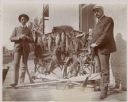
| Date: | 1905 |
|---|---|
| Description: | G.W. Roskie, left, of South Dakota, and Dr. Lange of Pittsburgh, Pennsylvania pose with their rifles on the porch of the Montello House Hotel. Between them... |

| Date: | 1921 |
|---|---|
| Description: | This map shows in red the NorthWestern Railway Line routes running from Chicago, Illinois to northern Wisconsin and Michigan. The map includes cities and t... |

| Date: | 1922 |
|---|---|
| Description: | This map shows in red the NorthWestern Railway Line routes running from Chicago, Illinois to northern Wisconsin. The map includes cities and towns, lakes, ... |
If you didn't find the material you searched for, our Library Reference Staff can help.
Call our reference desk at 608-264-6535 or email us at: