 Filter: Categories of Wisconsin Historical Images
Filter: Subject of Hunting
Filter: Subject of fishing
Filter: Categories of Wisconsin Historical Images
Filter: Subject of Hunting
Filter: Subject of fishing
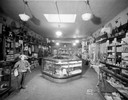
| Date: | 04 29 1932 |
|---|---|
| Description: | Interior of Felton Gun Store, located at 120 E. Washington Avenue, with elk, deer, and mountain goat heads mounted on the wall among the firearms and hunti... |

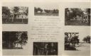
| Date: | 1870 |
|---|---|
| Description: | Bird's-eye view of Whitewater, with insets. |
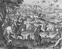
| Date: | 1655 |
|---|---|
| Description: | Scene near Jamestown Settlement in Virginia, ca. 1614. |
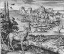
| Date: | 1655 |
|---|---|
| Description: | Scene from near Jamestown Settlement, ca. 1620. |

| Date: | 1914 |
|---|---|
| Description: | The Wolf River House. The advertisement reads: "The Wolf River House; Hunters' and Fishermen's Resort; Rates $1.50 per day - $9.00 per week; Special Rates ... |
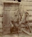
| Date: | 1900 |
|---|---|
| Description: | Man posed at door of a hunting lodge with guns, deer carcass, and two Northern pike. |
| Date: | |
|---|---|
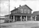
| Description: | A road passes in front of the Fish and Gun Club, a two-story building with people sitting and standing on the porch. Another dwelling stands beside it and... |
| Date: | 07 02 1925 |
|---|---|
| Description: | Photographic postcard of a poster promoting Camp Milo on White Sand Lake. On it are photographs of the cabins, tents, lake, and boats on the shore. |
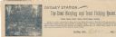
| Date: | |
|---|---|
| Description: | Letterhead of Dudley Station, a hunting and trout fishing resort in Dudley, Wisconsin. On the left is an illustration of a fisherman holding a fishing pole... |

| Date: | 1916 |
|---|---|
| Description: | This map shows the locations of hunting and fishing resorts in the northern Wisconsin counties of Forest, Iron, Oneida, and Vilas, and in Gogebic County in... |

| Date: | 1903 |
|---|---|
| Description: | A map of northern Wisconsin and Michigan showing the names and locations hunting and fishing resorts in the area, as well as location of Chicago and North ... |

| Date: | 1914 |
|---|---|
| Description: | Two maps of northern Wisconsin counties of Ashland, Barron, Bayfield, Chippewa, Douglas, Forest, Iron, Langlade, Lincoln, Oneida, Polk, Price, Sawyer, Tayl... |

| Date: | 1935 |
|---|---|
| Description: | This pictorial map of northern Bayfield County, Wisconsin, shows the Chequamegon National Forest, the Red Cliff Indian Reservation, highways and roads, and... |

| Date: | 1895 |
|---|---|
| Description: | This late 19th century map of northern Wisconsin and a portion of Michigan's Upper Peninsula shows the township and range grid, the (Lac du) Flambeau India... |

| Date: | 1986 |
|---|---|
| Description: | This late 1980s map of Price County, Wisconsin, shows facilities and lands open for public recreation, hunter walking trails and ski trails, campgrounds, b... |

| Date: | 1976 |
|---|---|
| Description: | Panel title. Shows railroads, roads, highways, boundaries, dams, public hunting and fishing grounds, cemeteries, forest ranger stations, plant life, and s... |
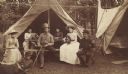
| Date: | 1888 |
|---|---|
| Description: | A group of young men and women posed before the tents of a hunting and fishing camp. |

| Date: | 1899 |
|---|---|
| Description: | View through trees towards a cabin. One man holding a rifle stands in the center at the left front side of the cabin, and a group of four men sit on the ri... |
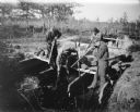
| Date: | |
|---|---|
| Description: | Four young men standing on a wooden platform over a stream, shooting rifles down into the water. Probably shooting fish. A dog is standing behind the group... |

| Date: | 1908 |
|---|---|
| Description: | This map shows counties, roads, Lake Superior, Lake Michigan, and portions of surrounding states. Also included is a list of railroads showing miles and g... |
If you didn't find the material you searched for, our Library Reference Staff can help.
Call our reference desk at 608-264-6535 or email us at: