 Filter: Categories of Wisconsin Historical Images
Filter: Subject of Hunting
Filter: Subject of cities and towns
Filter: Categories of Wisconsin Historical Images
Filter: Subject of Hunting
Filter: Subject of cities and towns
| Date: | |
|---|---|
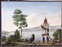
| Description: | Watercolor of Canadian Prairie Indian at lake's shore with gun in hand and a recently hunted duck on the ground. A dog is at his feet. On the far shoreline... |

| Date: | 1867 |
|---|---|
| Description: | Bird's-eye map of Green Bay and Fort Howard, Brown Co., depicts street names and street layouts, houses, trees, and the East River. A reference key at the ... |
| Date: | 11 27 1934 |
|---|---|
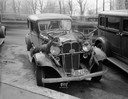
| Description: | A 14-point buck shot by Carl Laughnan, 4138 Mandan Crescent, and a 10-point buck shot by Russell Hegg, 330 Dow Court, are tied to the front fenders of the ... |

| Date: | 1870 |
|---|---|
| Description: | Bird's-eye view of Whitewater, with insets. |

| Date: | 1914 |
|---|---|
| Description: | The Wolf River House. The advertisement reads: "The Wolf River House; Hunters' and Fishermen's Resort; Rates $1.50 per day - $9.00 per week; Special Rates ... |

| Date: | |
|---|---|
| Description: | Group of men posed in front of small stone building with guns. Sign above doorway says "Waupun Hunters Club Home." |

| Date: | 1910 |
|---|---|
| Description: | Bringing in two small bucks, dead and loaded on a sled behind a team of horses, Old Camp 2. The third man from the right is Clarence Deitz. |
| Date: | 1900 |
|---|---|
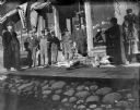
| Description: | A group of men stand in front of the Schwaller building on Pine Street with two male deer carcasses on the board sidewalk. The man touching the antlers is... |

| Date: | 1903 |
|---|---|
| Description: | A map of northern Wisconsin and Michigan showing the names and locations hunting and fishing resorts in the area, as well as location of Chicago and North ... |

| Date: | 1914 |
|---|---|
| Description: | Two maps of northern Wisconsin counties of Ashland, Barron, Bayfield, Chippewa, Douglas, Forest, Iron, Langlade, Lincoln, Oneida, Polk, Price, Sawyer, Tayl... |

| Date: | 1991 |
|---|---|
| Description: | This 1991 map of Burnett County, Wisconsin, shows Governor Knowles State Forest, wildlife areas, public hunting grounds, and other outdoor recreation facil... |

| Date: | 1895 |
|---|---|
| Description: | This late 19th century map of northern Wisconsin and a portion of Michigan's Upper Peninsula shows the township and range grid, the (Lac du) Flambeau India... |

| Date: | |
|---|---|
| Description: | Nine men posing while holding rifles in front of twelve deer strung up across First Street in front of the brick building that held Charles J. Van Schaick'... |

| Date: | 1908 |
|---|---|
| Description: | Copy photograph of an outdoor portrait of a group of men standing and kneeling in front of a line of deer suspended across First Street in Black River Fall... |

| Date: | 1910 |
|---|---|
| Description: | Group of twelve men and one boy posing on a dock. A dog lays at the feet of the man in the center. Three of the men hold stringers of dead ducks. On the fa... |
| Date: | 1910 |
|---|---|
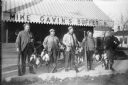
| Description: | Five duck hunters stand in front of Mike Gavin's Buffet holding guns, paddles, and stringers of dead ducks. |

| Date: | 1908 |
|---|---|
| Description: | This map shows counties, roads, Lake Superior, Lake Michigan, and portions of surrounding states. Also included is a list of railroads showing miles and g... |

| Date: | 1910 |
|---|---|
| Description: | This map shows counties, roads, Lake Superior, Lake Michigan, and portions of surrounding states. Also included is a list of railroads showing miles and gr... |
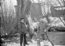
| Date: | |
|---|---|
| Description: | Exterior portrait of two hunters posing with a deer carcass, a fox carcass and rifles on the edge of a stream in winter. Buildings are in the background. |

| Date: | 1891 |
|---|---|
| Description: | This map shows soft marshland, water channels, solid ground, club boundary and shooting boxes. Big Lake, First Channel, Second Channel, Fout Mile Pond, Mal... |
If you didn't find the material you searched for, our Library Reference Staff can help.
Call our reference desk at 608-264-6535 or email us at: