Filter: Categories of Wisconsin Historical Images
Filter: Subject of Housing
Filter: Year of 1900-1999
Filter: Subject of cities and towns
Filter: Categories of Wisconsin Historical Images
Filter: Subject of Housing
Filter: Year of 1900-1999
Filter: Subject of cities and towns
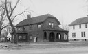
| Date: | 1910 |
|---|---|
| Description: | Dr. and Mrs. Philip R. and Katherine B. Fox residence at 28 West Wilson Street, corner of South Carroll Street. The house was constructed of Milwaukee bric... |

| Date: | 06 07 1954 |
|---|---|
| Description: | Aerial view of the Midvale neighborhood under construction showing the intersection of Midvale and Tokay Boulevards near the southwestern city limits of Ma... |
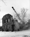
| Date: | 1970 |
|---|---|
| Description: | Historic home on University Avenue being demolished. The home was replaced by Burger King, a fast-food, drive-in restaurant. |
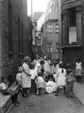
| Date: | 07 1923 |
|---|---|
| Description: | Children at play in a dirt alley on Chicago's west side. |
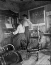
| Date: | 1900 |
|---|---|
| Description: | A woman sits at a reed organ while another looks on. |
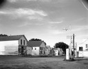
| Date: | 07 05 1965 |
|---|---|
| Description: | Street corner with gasoline station, 7-Up sign in front of restaurant next door, and several storefronts across the street. |
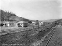
| Date: | 11 02 1918 |
|---|---|
| Description: | Residential building site near railroad tracks, looking west. Several houses are under construction. Benham was a "company town" created by International H... |
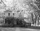
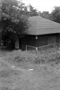
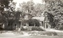
| Date: | 08 11 1960 |
|---|---|
| Description: | Exterior of a house surrounded by backlit trees. |
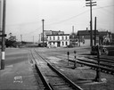
| Date: | 11 12 1936 |
|---|---|
| Description: | Chicago & Northwestern Railroad tracks, looking east at the crossing of S. Blair Street, King Street, E. Wilson Street, and Williamson Street. Included in ... |

| Date: | 1945 |
|---|---|
| Description: | View of the lower campus of the University of Wisconsin-Madison includes Bascom Hill, Wisconsin Historical Society, Memorial Union and the Armory (Red Gym ... |
| Date: | 1954 |
|---|---|
| Description: | Elevated view of lower Sunset Village looking northwest from Sunset Point. University Hill Farm is on the left and Shorewood Hills is on the right. |
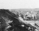
| Date: | 1925 |
|---|---|
| Description: | Elevated view from a hill of an alley connecting Park Hill Avenue and Mount Vernon Avenue, looking west from the Interurban Line. There is a person on top ... |

| Date: | 08 29 1966 |
|---|---|
| Description: | Father James Groppi leading a fair housing march. |
| Date: | 07 24 1946 |
|---|---|
| Description: | View down hill towards a building, probably on the grounds of the Winnebago (Ho Chunk) Indian Village. |
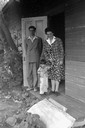
| Date: | 06 24 1946 |
|---|---|
| Description: | Helene Stratman-Thomas with an unidentified man and child, possibly at Winnebago (HoChunk) Indian Village. |

| Date: | 1915 |
|---|---|
| Description: | Exterior view of the Frederick Karberg house located at 25 North Blair Street. The house was later moved to the corner of East Johnson and North Livingston... |
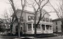
| Date: | 1930 |
|---|---|
| Description: | The Trimpey's home, the residence of Edwin B. and Alice Kent Trimpey. View of the front entrance door and front porch facing the street. |
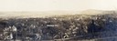
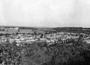
| Date: | 1900 |
|---|---|
| Description: | Aerial view of town, with houses in foreground, and hills on the horizon in the background. Caption reads: "Baraboo, Wis." |
If you didn't find the material you searched for, our Library Reference Staff can help.
Call our reference desk at 608-264-6535 or email us at: