 Filter: Categories of Wisconsin Historical Images
Filter: Subject of Hotels
Filter: Subject of lumber trade
Filter: Categories of Wisconsin Historical Images
Filter: Subject of Hotels
Filter: Subject of lumber trade

| Date: | 1874 |
|---|---|
| Description: | Bird's-eye map of Chippewa Falls. |

| Date: | 1896 |
|---|---|
| Description: | Bird's-eye view of Washburn, with twenty vignettes around side, water in foreground with docks and lumber corral. Thirty-three locations identified in key ... |
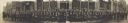
| Date: | 02 27 1908 |
|---|---|
| Description: | Panoramic view of the Fifth Annual Convention of Western Retail Lumbermen's Association, including the Association members and Lumbermen's Mutual Society. ... |
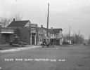
| Date: | 1924 |
|---|---|
| Description: | View across railroad tracks of storefronts located near the train depot. The shops include: Montford Lumber Company, Damerow's Cafe, and the American Hotel... |

| Date: | 1892 |
|---|---|
| Description: | A Sanborn map of St. Louis, which is six miles southwest of South Superior. |

| Date: | 10 1894 |
|---|---|
| Description: | A Sanborn Fire Insurance Map of Waunakee. |

| Date: | 1892 |
|---|---|
| Description: | A Sanborn fire insurance map of Sauk City which was drawn up in 1892. |

| Date: | 1900 |
|---|---|
| Description: | A Sanborn fire insurance map of Sauk City created in 1900. |
If you didn't find the material you searched for, our Library Reference Staff can help.
Call our reference desk at 608-264-6535 or email us at:

