Filter: Categories of Wisconsin Historical Images
Filter: Subject of Hotels
Filter: Subject of architecture
Filter: Year of 1800-1899
Filter: Year of 1860-1869
Filter: Categories of Wisconsin Historical Images
Filter: Subject of Hotels
Filter: Subject of architecture
Filter: Year of 1800-1899
Filter: Year of 1860-1869

| Date: | 1867 |
|---|---|
| Description: | Bird's-eye map of Green Bay and Fort Howard, Brown Co., depicts street names and street layouts, houses, trees, and the East River. A reference key at the ... |
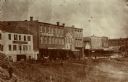
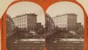
| Date: | 1869 |
|---|---|
| Description: | View from across the railroad track. The Milwaukee and St. Paul Railroad car #4770 is in the foreground. The Freeman House, Carlisle House and Empire Stove... |
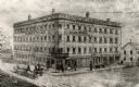
| Date: | 1860 |
|---|---|
| Description: | Elevated view of the Durkee House built by Charles Durkee in 1843. |
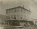
| Date: | 1860 |
|---|---|
| Description: | View across intersection towards the Alba House, with individuals standing outside its entrance and on the balcony. |

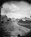
| Date: | 1868 |
|---|---|
| Description: | Stereograph view of the levee, with buildings along the left. Signs on the buildings read, left to right: "(?) Hotel", "Saloon" and "Dunbar's Hall." People... |
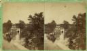
| Date: | 1860 |
|---|---|
| Description: | Stereograph of the Townsend House boathouse across a lake. |
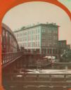
| Date: | 1869 |
|---|---|
| Description: | Stereograph of the Axtell House building, with a storefront next to it advertising "Clothing Hats Caps Sailors Outfits". A bridge is on the left and a man... |
| Date: | 1869 |
|---|---|
| Description: | Stereograph of the Axtell House building, with a storefront next to it advertising "Clothing Hats Caps Sailors Outfits". A bridge is on the left and a man... |

| Date: | 1860 |
|---|---|
| Description: | Stereograph of the Townsend House boathouse across a lake. |
If you didn't find the material you searched for, our Library Reference Staff can help.
Call our reference desk at 608-264-6535 or email us at: